Matrice 4 in Mountain Construction Work: What Actually
Matrice 4 in Mountain Construction Work: What Actually Matters When the Weather Turns
META: A technical review of Matrice 4 for mountain construction site capture, focused on changing weather, photogrammetry reliability, thermal signature use, transmission stability, battery workflow, and real-world operational significance.
By Dr. Lisa Wang
Mountain construction surveying punishes weak assumptions.
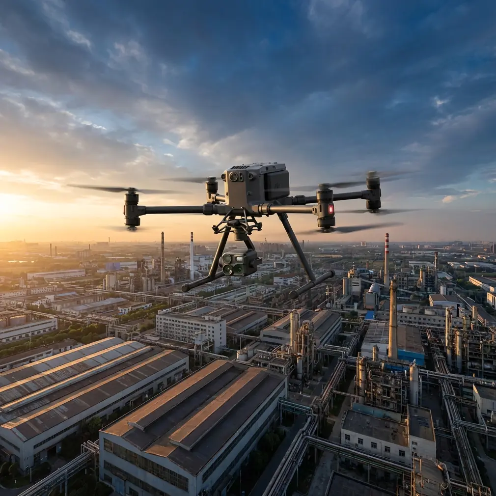
A drone that behaves perfectly on a flat suburban test field can start showing its limits the moment terrain steps upward, wind curls around a ridge, and the light shifts every few minutes. That is why the Matrice 4 conversation gets more interesting when it leaves the spec sheet and enters a real hillside job: cut-and-fill tracking, access-road progress checks, slope stability observation, and thermal inspection of temporary electrical systems or drainage anomalies.
This review looks at Matrice 4 through that lens. Not as a generic enterprise aircraft, but as a platform for capturing construction sites in mountains, where weather and terrain pressure every subsystem at once.
Why mountain jobs expose the truth
A mountain site asks one aircraft to do several things well at the same time.
It has to hold a stable data link when the pilot is not standing in the ideal line-of-sight position. It has to produce usable photogrammetry despite uneven elevations and changing shadows. It should support thermal signature work when visible imagery is compromised by haze or late-day contrast. And battery workflow cannot become the bottleneck, because every extra landing on a narrow work pad costs time and often breaks mapping continuity.
Those demands are why operators keep returning to a few practical questions:
- Can the transmission link stay solid when the aircraft drops behind terrain features?
- Can it keep producing mapping-grade image sets when weather changes mid-flight?
- Does the battery system support a professional mountain workflow rather than a stop-start hobby rhythm?
- Can the security and data chain satisfy construction, engineering, and asset-owner requirements?
Matrice 4 earns attention because it is built for exactly these kinds of operational pressures.
The transmission question matters more in mountains than almost anywhere else
On urban roofs, pilots often talk about camera quality first. In mountain construction, transmission can be the bigger story.
That is where O3 transmission becomes operationally significant. A robust digital link is not just about seeing a clean live feed. It affects flight confidence, framing discipline, route adherence, and whether you can maintain a safe and efficient mission when the aircraft is transitioning across elevation changes or skirting a slope face. On mountain jobs, signal quality determines whether the pilot is calmly managing the mission or constantly repositioning and second-guessing the aircraft.
The practical consequence is simple: better link stability supports more consistent image overlap during photogrammetry missions. That matters because mountain sites rarely forgive a weak dataset. If a section of haul road or retaining work needs to be reflown, crews may already have moved plant equipment, changing the scene and reducing comparability with the first pass.
A reliable transmission chain also supports safer stand-off positioning. On some sites, the best pilot location for visibility is not the safest location for people, vehicles, or edge protection. Better link resilience gives the team more flexibility in choosing ground control and pilot stations without compromising situational awareness.
Mid-flight weather changes are where aircraft character shows
One recent mountain-style workflow illustrates this well.
The mission began under acceptable visibility with crisp morning contrast across excavation terraces. About halfway through the flight, conditions shifted. A crosswind developed along the slope, low cloud started flattening the scene, and the sun disappeared behind a fast-moving layer. The site went from ideal photogrammetry light to a more difficult, lower-contrast environment in minutes.
This is where a lot of operators make the wrong judgment. They treat weather change as only a flight stability issue. In reality, it is also a data-quality issue.
The Matrice 4 handled the shift in two ways that matter for construction capture. First, the aircraft remained predictable enough to preserve mission discipline rather than forcing an improvised manual rescue of the route. Second, the sensor workflow still allowed useful collection after visible detail started losing separation in shadowed areas. That is where thermal signature capability becomes more than a niche checkbox.
On mountain projects, thermal data can reveal things visible imagery may miss under unstable weather: moisture patterns along a cut slope, drainage irregularities, heat from overloaded temporary power components, or temperature differences in newly installed infrastructure. It is not a replacement for photogrammetry. It is a second layer of site intelligence that becomes especially valuable when the weather starts working against your visual dataset.
In difficult conditions, that dual-use flexibility can save a mission day.
Photogrammetry in mountains lives or dies on discipline
Photogrammetry over mountain construction is not just standard mapping with prettier scenery. Elevation changes distort easy planning assumptions.
Your overlap strategy, terrain following, and GCP placement all have more influence than many teams expect. With Matrice 4, the aircraft side of the equation is only part of the story. The real advantage comes when the platform’s stability and mission tools are paired with disciplined site control.
GCPs remain essential on serious mountain jobs. Yes, modern enterprise drones can generate highly capable datasets, but when the site includes switchback roads, terraced benches, retaining structures, and variable vertical surfaces, ground control is what turns “good-looking output” into engineering-trustworthy output. A site with poor GCP geometry often hides errors until a volume comparison or alignment check exposes them.
This is where weather timing intersects with workflow. If light changes mid-flight, image consistency can degrade. The operator’s goal is not perfection; it is recovery without dataset failure. A stable aircraft and dependable transmission allow the pilot to finish the mission cleanly, note the environmental shift, and make better decisions in post-processing rather than dealing with broken coverage.
The deeper point is that Matrice 4 helps preserve process integrity. In mountain construction, that is often more valuable than a headline feature.
Battery management decides whether your day flows or stalls
Mountain projects create awkward battery cycles. Launch zones are rarely comfortable. Vehicles may be parked below grade. Teams may need to move between pads or operate from temporary access points. In those conditions, hot-swap batteries are not a luxury. They are workflow insurance.
Hot-swap capability has obvious time value, but the larger benefit is continuity. When you can exchange power quickly without turning every battery change into a full operational reset, you reduce downtime and maintain survey momentum. That matters when the weather window is narrow, which it often is in elevated terrain.
A mountain crew might only get one calm, usable interval before wind or cloud closes in. Fast turnaround between sorties means more than convenience; it can be the difference between completing a progression dataset and going home with half a model.
There is also a human-factor benefit. Frequent, cumbersome battery procedures on unstable or muddy ground increase the chance of rushed handling and simple mistakes. Cleaner battery workflow supports safer operations and more consistent mission pacing.
Security is no longer a side note for construction drone programs
Many construction stakeholders now expect a clear answer to one question: how is the project data protected?
That is why AES-256 should be treated as an operational feature, not a marketing bullet. Mountain construction capture often involves sensitive information: progress records, infrastructure layouts, contractor performance evidence, utility routing, and pre-handover documentation. Secure transmission and data handling reduce friction with asset owners, consultants, and project managers who need confidence that aerial records are not casually exposed.
In practice, that means Matrice 4 fits more comfortably into enterprise environments where the drone team is not working in isolation. Survey, engineering, commercial management, and client-side oversight all touch the resulting data. Security standards influence whether the drone program is seen as dependable infrastructure or just an interesting field tool.
What the wider aircraft world tells us about Matrice 4 priorities
A recent aviation milestone helps frame why these details matter.
On April 29, the East China Regional Administration of the CAAC formally accepted the type certificate application for Tianlingke’s L600 Pioneer. According to the report, this made it the first company to enter the airworthiness certification stage for a hybrid crewed eVTOL. The aircraft is described as a hybrid extended-range full-tilt ducted-wing platform with fuel-generated power and redundant battery design, capable of a 600 km maximum range, 360 km/h cruise speed, and a 500 kg payload for 1 pilot plus 5 passengers.
Why bring up a crewed eVTOL in a Matrice 4 review for construction sites?
Because it highlights where serious aviation development is heading: redundancy, certification discipline, and practical operation in complex environments. Even though Matrice 4 sits in a very different class from a crewed eVTOL, the same operational logic applies. Reliability is not one feature. It is a system philosophy.
That report’s mention of redundant battery design is especially relevant. In professional drone operations, power architecture and mission continuity are central to trust. Mountain construction operators do not need a futuristic narrative. They need an aircraft that keeps working when the environment becomes untidy.
There is another useful parallel from conventional aircraft design literature. Structural engineering references emphasize modal behavior, low-frequency engineering significance, and the need to reduce complexity without losing critical fidelity. In plain language, the important behavior is often found in the modes that most affect real operation. That same mindset is useful when assessing drones. Ignore the noise. Focus on the characteristics that dominate field performance: link integrity, stable capture, battery workflow, and data security.
For mountain site teams, those are the low-frequency truths of the mission.
Cabin design lessons, oddly enough, still apply
Even a civil aircraft interior handbook offers a relevant clue. It discusses visible emergency markings, illuminated and non-illuminated signage, and the placement of critical indicators near exits and equipment storage points. The exact aircraft context is different, but the design principle carries over: information must remain clear under stress, low visibility, and changing conditions.
That matters in drone operations more than people admit. In mountain weather, cockpit clarity, app readability, alert logic, and workflow simplicity all become operational assets. The less cognitive clutter the pilot deals with, the better the mission outcome when conditions deteriorate unexpectedly.
Good enterprise drone systems reduce ambiguity. They help the operator see what matters, react quickly, and keep the mission orderly.
Where Matrice 4 fits best on mountain construction sites
Matrice 4 is strongest when the job requires multiple outputs from a single deployment.
It fits well when a team needs:
- routine progress capture over irregular terrain
- photogrammetry for earthworks and access roads
- thermal signature review of drainage, utilities, or temporary infrastructure
- repeatable missions under inconsistent weather windows
- secure handling of project imagery and engineering data
It is less about one dramatic capability and more about operational composure. That is a useful distinction. Mountain construction punishes glamorous platforms that are awkward to live with day after day.
If your team is building a repeatable site-capture program rather than flying occasional showcase missions, Matrice 4 makes sense for reasons that do not always show up in a product headline.
A few practical tips that improve results immediately
Use terrain-aware planning wherever possible. Mountain sites are vertical problems disguised as horizontal ones.
Place GCPs across elevation bands, not just around the easy flat edges. Good geometry matters more than convenient geometry.
Treat thermal as a complementary layer, not an afterthought. When weather shifts and visible contrast collapses, thermal may preserve useful inspection value.
Build battery rotation around the weather window, not the clock. Hot-swap efficiency is best used to compress downtime while conditions are still favorable.
Choose your pilot position for both safety and link quality. O3 transmission helps, but smart siting still matters.
If you need a field workflow discussion specific to mountain construction capture, this direct WhatsApp line is useful for comparing mission setups.
Final assessment
Matrice 4 stands out in mountain construction work because it addresses the problems that actually interrupt deliverables.
Not abstract performance. Not showroom talking points. Real obstacles: broken terrain, shifting weather, inconsistent visibility, battery turnover, and enterprise data handling.
The strongest case for the platform is not that it can fly a mission in ideal conditions. Many aircraft can do that. The stronger case is that when the wind freshens halfway through a slope survey and the light falls apart, the aircraft still gives the operator a path to finish the job with usable results.
That is the standard that matters on a mountain site.
Ready for your own Matrice 4? Contact our team for expert consultation.