Delivering Through Vine Rows at Dusk: How the Matrice 4
Delivering Through Vine Rows at Dusk: How the Matrice 4 Changes Low-Light Vineyard Operations
META: Expert analysis of using Matrice 4 for low-light vineyard delivery, imaging, and operational reliability, including thermal workflows, O3 transmission, antenna tuning, AES-256 security, hot-swap batteries, and photogrammetry support.
Vineyards look orderly from the road. From the air, especially after sunset, they become something else entirely: repeating lines, narrow corridors, elevation changes, metallic trellis systems, irrigation hardware, cold pockets, and signal reflections that can turn a routine drone task into a messy one fast.
That matters when the mission is delivery in low light.
Not long ago, sending a UAV into a vineyard at dusk meant accepting several compromises at once. Visual detail dropped off. Terrain depth became harder to judge. Wireless performance could get unreliable near infrastructure or on rolling ground. And if the job involved moving urgently needed field items between blocks—replacement sensors, small tools, sample kits, medical supplies for a crew, or crop treatment diagnostics—the margin for delay widened exactly when time mattered most.
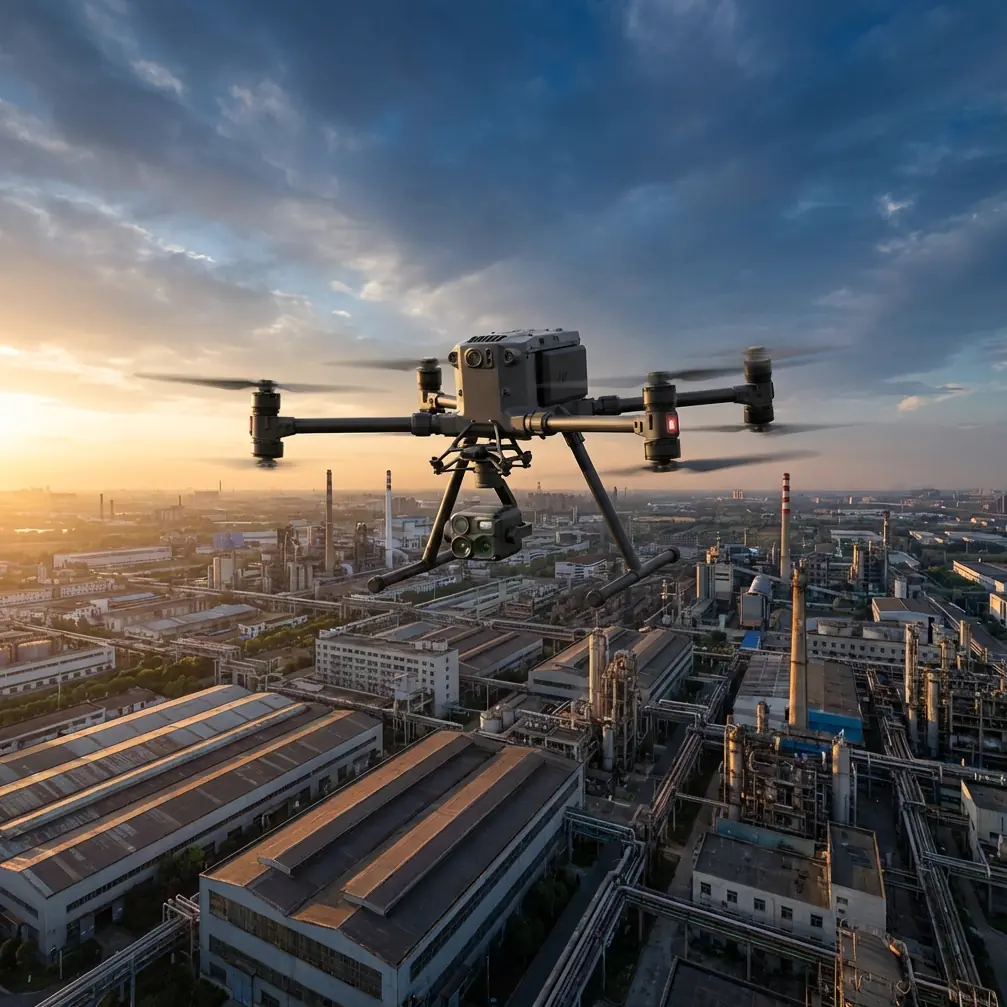
The Matrice 4 is interesting here not because it is simply “more advanced,” but because it brings together several systems that directly address the weak points of low-light rural operations. In vineyard work, that combination is what counts.
The real problem is not darkness alone
Low-light delivery sounds straightforward until you define the environment.
A vineyard is not an empty field. Rows can create visual monotony that confuses depth perception. Moist air and cooling ground temperatures alter visibility and airflow. Trellis wires and support posts create fine-structure clutter. Utility hardware, pumps, weather stations, and nearby buildings can add electromagnetic noise. If the site spans slopes, the pilot is also dealing with line-of-sight interruptions and shifting link quality.
For a conventional workflow, the bottleneck is rarely just payload movement. It is confidence.
Can the aircraft hold a robust link as it crosses rows and dips behind contour lines? Can the operator distinguish a warm vehicle, a worker, irrigation equipment, and a harmless patch of retained heat in the soil? Can the mission continue without a long turnaround if battery reserves tighten at the wrong block? Can mission data be trusted later for documentation, compliance, and planning?
Those are the questions that separate a demonstration flight from a tool crews rely on.
Why thermal signature matters in vineyards after sunset
One of the easiest mistakes in low-light operations is assuming the night mission is just a daytime mission with fewer photons. It is not. Once the sun drops, heat tells a different story than visible light.
Thermal signature becomes operationally valuable in vineyards for three reasons.
First, it helps identify active human and vehicle presence around loading and drop zones. In a working vineyard, crews may still be moving between rows, especially during harvest or frost-response windows. At dusk, visible contrast can be weak. Thermal contrast often is not. That changes risk assessment in a practical way.
Second, thermal imaging can reveal environmental conditions that influence route choice. Irrigated areas, cool drainage channels, recently used machinery, pump stations, and storage zones all present different heat patterns. A pilot who understands these signatures is not just “seeing in the dark”; they are reading the site.
Third, thermal data can support adjacent workflows beyond delivery. If the same team is already checking for stressed irrigation zones, blocked lines, overheated electrical components, or equipment anomalies, the aircraft becomes more than a courier. It becomes part of the vineyard’s operating intelligence.
That is the kind of dual-use efficiency managers actually keep.
O3 transmission is not a spec-sheet footnote
For rural delivery, transmission reliability is central. A low-light mission over vineyards often stretches across uneven terrain where rows and rises can interrupt signal quality. This is where O3 transmission matters operationally.
The value is not abstract bandwidth. It is stable situational awareness when the aircraft is moving through a site that keeps changing the radio environment. In practice, strong transmission means smoother command response, cleaner video feedback, and less guesswork when the aircraft transitions from open sky over one block to a partially obstructed path near structures or topographic breaks.
The more complex issue is electromagnetic interference. Vineyards can be deceptively noisy. Pump systems, metal supports, nearby utility assets, and even temporary field equipment can affect link consistency. When interference starts building, pilots sometimes blame the aircraft too quickly. Often the fix begins with antenna discipline.
A simple antenna adjustment can make a measurable difference. Not a random wave of the controller, but deliberate alignment to maintain the strongest relationship between antennas and aircraft path. In rolling vineyard terrain, that may mean changing stance, rotating position as the drone enters a different block, or elevating the controller’s orientation to avoid partial shielding by vehicles or structures. Operators who treat antenna geometry seriously usually see the link stabilize faster than operators who chase the problem with unnecessary route changes.
That is one of those unglamorous habits that saves missions.
AES-256 is not just about IT policy
Agricultural flight operations generate more sensitive data than many people assume. Vineyard maps, block health assessments, operational schedules, route records, and infrastructure imagery all have business value. If a Matrice 4 deployment is moving between delivery work and mapping or inspection tasks, data security stops being a back-office issue.
AES-256 matters because it gives operators and managers a credible standard for protecting transmission and mission data in a professional environment. For estate vineyards, contract growers, and agronomy service providers, that matters when operations involve multiple stakeholders and shared datasets. A drone system trusted for site intelligence is easier to deploy across more tasks.
Security affects adoption. Adoption affects utilization. Utilization is where return really comes from.
Hot-swap batteries change field rhythm
Battery management is where many low-light workflows lose efficiency. The aircraft may be capable, the route may be valid, but the field team burns time on avoidable downtime.
Hot-swap batteries are one of those features that look ordinary until the operation gets busy. In a vineyard spread across multiple blocks, crews often need quick redeployment. Maybe one mission delivers a replacement moisture sensor to a technician near the north slope, and the next mission shifts immediately to imaging a suspected irrigation fault in an adjacent parcel. If battery changes are slow, the rhythm breaks.
Hot-swap support keeps the aircraft in rotation.
That is especially valuable at dusk, when the useful operational window can be short. Light falls off quickly. Crew availability narrows. Temperature shifts can change conditions block by block. Saving a few minutes between sorties is not cosmetic; it can determine whether the team completes one mission or three.
For managers planning recurring vineyard operations, this also improves staffing logic. Pilots spend less time waiting and more time executing.
Delivery becomes smarter when paired with photogrammetry
At first glance, photogrammetry and delivery seem like separate worlds. They are not.
A vineyard that has already been modeled well gives low-light delivery flights a better planning baseline. Photogrammetry provides accurate terrain representation, row spacing context, obstacle awareness, and dependable route planning. Add GCP-based control points to tighten spatial accuracy, and now the site model is not just visually useful; it is decision-grade.
This has direct operational significance.
If the delivery route crosses terraces, drainage cuts, equipment storage pads, or uneven canopy height, a precise map reduces surprises. If loading and drop locations have been surveyed against GCP references, teams can define repeatable delivery positions with far more confidence than they could using rough visual landmarks alone. Over time, that consistency lowers pilot workload and improves handoff reliability to ground crews.
This is where a Matrice 4-centered workflow starts to stand out. The aircraft is not only a vehicle for urgent point-to-point transport. It can sit inside a broader site-management stack that includes thermal review, visual inspection, and photogrammetric planning.
For vineyard operators, tools that do one thing are easy to admire. Tools that connect workflows are the ones that stay booked.
BVLOS conversations need realism, not bravado
Any serious discussion about vineyard delivery eventually touches BVLOS. The appeal is obvious. Large estates and remote parcels can make beyond visual line of sight operations attractive from a productivity standpoint. But the mature approach is not to romanticize the idea. It is to treat BVLOS as a framework that depends on regulation, risk controls, route design, communication procedures, and site-specific validation.
Where Matrice 4 fits into that conversation is through the combined value of transmission reliability, secure communications, mapping support, and battery workflow. Those elements do not “solve” BVLOS on their own, but they do support the kind of disciplined operating model required for advanced missions when legally authorized.
For vineyards, the practical takeaway is simpler: even if the current operation remains within visual line of sight, building the mission architecture with BVLOS-grade thinking improves present-day safety and repeatability. Better maps. Better link management. Better contingency planning. Better crew coordination.
That mindset pays off now, not just later.
A field scenario that shows the difference
Picture a late-evening request from a vineyard team on a hillside block. A technician needs a replacement sensor module and calibration kit before the night temperature swing sharpens. The access track is slow, and a utility vehicle would take too long. The mission launches from a central operations point.
The pilot already has a photogrammetric model of the estate built with GCP-backed references. The route avoids known utility structures and follows a corridor with cleaner approach geometry. As the aircraft crosses a section with metal trellis concentration and pump equipment nearby, the video link begins to soften. Instead of overcorrecting, the pilot adjusts antenna orientation to better match the aircraft’s path and heading. Link quality steadies.
Near the destination, visible contrast is weak, but thermal signature clearly separates a parked vehicle, two workers, and a still-warm pump housing from the designated handoff area. The drop is completed without confusion. The aircraft returns, battery is changed through a hot-swap workflow, and a second sortie launches to inspect an irrigation anomaly flagged earlier in the same block.
That sequence is not science fiction. It is what happens when the aircraft, the data, and the operating method are aligned.
If your team is trying to design that kind of workflow around real vineyard constraints, this direct WhatsApp line for mission planning is a practical place to start.
What makes Matrice 4 specifically useful here
The short answer is integration.
Low-light vineyard delivery is not won by one standout capability. It is won by a stack of capabilities that reduce uncertainty at the exact points where field operations tend to wobble. Thermal signature helps pilots interpret the site when visible detail fades. O3 transmission supports command confidence across difficult ground. AES-256 addresses the reality that operational data in agriculture has value and needs protection. Hot-swap batteries preserve mission tempo. Photogrammetry and GCP workflows make route planning repeatable rather than improvised.
Each of those details matters on its own. Together, they change the quality of the mission.
And that is the real threshold for professional UAV deployment in agriculture. The aircraft has to do more than complete a flight. It has to make the operation calmer, clearer, and easier to repeat tomorrow under slightly worse conditions.
The Matrice 4 fits that standard well in vineyard work, especially when the schedule does not stop just because daylight does.
Ready for your own Matrice 4? Contact our team for expert consultation.