Matrice 4 Over Urban Power Lines: A Field Report on Control
Matrice 4 Over Urban Power Lines: A Field Report on Control, Documentation, and Mid-Flight Decision-Making
META: Expert field report on using Matrice 4 for urban power line filming, with practical insight on documentation, system clarity, weather shifts, and safe commercial UAV operations.
Urban power line work exposes the difference between a drone that merely flies well and a drone system that can stay organized when conditions become messy. That distinction matters more than most spec sheets suggest.
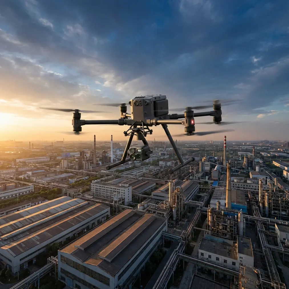
On a recent Matrice 4 deployment for filming power lines in a dense urban corridor, the job looked straightforward at first glance: collect stable visual coverage of conductor routes, insulator clusters, pole-top hardware, and surrounding encroachment risks without disrupting traffic flow below. The twist came later. Weather changed mid-flight. Wind shifted through the street canyons between towers, ambient temperature dropped enough to alter the scene’s thermal signature, and the mission had to be adjusted without losing coverage continuity.
That is where the real story begins.
Why urban power line filming is harder than it sounds
Filming power infrastructure in a city is not just a matter of putting a camera in the air and tracing the line. The aircraft is working in a visual environment full of vertical clutter, reflective surfaces, radio noise, and changing airflow. Add moving vehicles, rooftop turbulence, and patchy GPS geometry near high-rise structures, and every pass becomes a controlled exercise in risk management.
For the Matrice 4 operator, the challenge is not only aerial stability. It is system readability. You need to understand what the aircraft is doing, what the payload is seeing, what the transmission link is carrying back, and how the crew interprets that information fast enough to make good decisions.
That is why one of the most useful ideas hidden in the reference material has nothing to do with drones directly. The aircraft design handbook emphasizes that technical information should be standardized and presented with diagrams so even non-specialists can understand system and subsystem functions. It specifically highlights block diagrams as a way to simplify complex circuits and signal flows into something operationally clear.
That principle carries over almost perfectly to Matrice 4 fieldwork.
When you are filming power lines in an urban environment, the crew should not be relying on memory and verbal shorthand alone. The mission works better when the aircraft, payload, transmission path, battery plan, and emergency actions are broken into simple visual logic. A clean block-style workflow—aircraft, payload, operator, observer, data capture, handoff—reduces hesitation. It also helps utility clients understand why a pilot aborted one line segment and re-ran it from a safer angle after the wind changed.
In practice, that kind of clarity saves time.
The pre-flight structure that actually matters
Before launch, we built the mission around three capture layers.
First, standard visual passes for asset condition and corridor context. These establish the relationship between the power line and the built environment: balconies, trees, rooftop equipment, signage, telecom attachments, and traffic routes.
Second, thermal signature review. Urban power infrastructure often sits against confusing backgrounds—sun-warmed facades, reflective glazing, HVAC discharge, and asphalt heat plumes can all contaminate interpretation. Thermal is useful, but only if the team understands what it is looking at and records the environmental context at the same time.
Third, photogrammetry support passes where geometry and overlap made sense. Not every urban power line mission needs a full reconstruction workflow, but when pole geometry, clearance concerns, or repeatable condition baselines are needed, planning around photogrammetry and later tie-in with GCP-backed survey control can turn “video collection” into an actual asset record.
That broader planning mindset matters with Matrice 4 because the aircraft is often selected not just for image capture, but for multi-sensor inspection logic. If the customer starts by asking for footage, they often end by asking for traceable documentation.
A note on transmission discipline in the city
Urban flights test link confidence in ways open-field jobs do not. O3 transmission performance is helpful here because stable situational awareness is not a luxury when your aircraft is working around utility structures, reflective building surfaces, and layered RF noise. A strong link is not just about prettier monitoring. It supports tighter crew coordination and cleaner decision-making when the pilot needs to reposition quickly.
On this mission, transmission stability mattered most when the weather shifted. We were halfway through a lateral sequence along the line when the wind began curling around a mid-rise block and pushing the aircraft off the preferred camera path. The drone was still entirely manageable, but the nature of the footage changed. Smooth orbital framing around a pole-top assembly became less efficient than a shorter offset pass with more conservative lateral spacing.
Because the live feed remained dependable, the crew could make that change immediately instead of dragging the mission into uncertainty.
For utility work in populated zones, that is the value of a robust transmission system: it keeps the operation readable under pressure.
When the weather changed mid-flight
The city had been warm at takeoff. Not hot, but enough to flatten some thermal contrast on sun-exposed hardware. Then a front moved in faster than forecast. Wind picked up first. Light quality shifted next. Surface temperatures started dropping unevenly depending on material and shade.
This is the sort of moment that exposes whether a crew is truly inspecting or just collecting footage.
On the visual side, the changing light improved detail on some metal fittings by reducing glare. On the thermal side, the evolving scene made interpretation trickier in one respect and more useful in another. Some components separated more clearly from the background as the environment cooled. Others became harder to compare directly against earlier captures from the start of the flight.
So we adapted. Instead of treating the mission as one continuous visual narrative, we segmented the record by environmental phase. That simple choice preserved interpretive value. Later, when reviewing the files, it was obvious which thermal observations belonged to the warmer pre-shift window and which belonged to the cooler post-shift window.
This is exactly where disciplined documentation matters as much as aircraft performance.
And another detail from the reference material becomes surprisingly relevant. The maintenance-publication guidance argues for simplified explanatory diagrams and standardized organization because complex systems become usable only when their functions are presented clearly. In drone inspection terms, your imagery alone is not enough. Your field notes, screen captures, flight labels, subsystem references, and maintenance-style graphics are what convert raw media into a usable inspection package.
A utility stakeholder rarely needs every technical nuance of the aircraft. They need to understand what was flown, what changed, what was observed, and what should be reviewed next.
The operational significance of decision thresholds
The most technical reference provided concerns thrust reversal on manned aircraft, but one concept translates cleanly into serious UAV operations: termination thresholds matter.
The source states that once reverse-thrust exhaust is re-ingested into the intake, engine performance can deteriorate sharply because of pressure distortion and elevated temperature ahead of the compressor. It also notes that determining the minimum speed at which reverse thrust use must stop is a critical design question. In that example, even properly integrated reverse-thrust systems still carry measurable penalties—generally nozzle thrust loss not exceeding 1% and specific fuel consumption increase not exceeding 2.5%, with the DC-10 CF-6 example cited at a 1% thrust drop and 2.2% SFC increase.
Why should a Matrice 4 operator care?
Not because the drone uses reverse thrust. It does not. The lesson is about respecting mode limits and environmental thresholds before performance degrades into a safety issue. In the field, that means defining in advance the conditions that trigger a change in plan: maximum crosswind for lateral line tracking, minimum visibility for conductor separation, thermal conditions that invalidate comparison shots, battery reserve margins for urban recovery routing, and transmission confidence below which precision inspection passes are no longer justified.
The reference’s reverse-thrust example shows that even highly engineered systems involve tradeoffs and hard stop criteria. Good UAV crews think the same way. They do not treat “still flyable” as equivalent to “still worth flying this profile.”
When the weather changed on our mission, we did not continue the original pass plan just because the Matrice 4 remained controllable. We shifted to a narrower objective: finish the most critical pole-top imagery, preserve corridor context, and postpone the detailed thermal comparison set for a better environmental window.
That decision improved the quality of the final deliverable.
Hot-swap thinking, even when time is tight
Power line filming often creates a subtle pressure to stay airborne a little longer. One more pole. One more angle. One more thermal sweep.
That mindset produces sloppy recoveries.
The better approach is to structure the sortie around clean segments and battery discipline. If your platform and workflow support efficient battery rotation, use that advantage to keep capture quality high rather than stretching a single flight. Hot-swap batteries are especially valuable in urban utility work because they let the crew preserve momentum while still resetting for better camera settings, a revised route, or a weather-based adjustment.
This becomes even more important if the client expects repeatable observations over multiple line sections. Consistency beats endurance theater every time.
Security and data handling are part of the field job
Urban infrastructure imagery can contain more than utility assets. It may incidentally capture rooftops, private property, building access points, and commercial facilities. That means transmission and storage discipline matter. If your workflow includes AES-256 data protection, that should not be treated as a marketing bullet. It is part of responsible infrastructure handling.
The same logic applies to file naming, card management, and post-flight segregation of thermal, visual, and mapping outputs. Again, the maintenance-documentation reference is useful here: standardization is not bureaucracy for its own sake. It reduces ambiguity. Ambiguity is expensive.
For teams building repeat business in utility inspection, better documentation often matters as much as better flying.
BVLOS talk needs realism
BVLOS comes up constantly in utility corridor discussions because linear assets naturally invite long-range thinking. But in an urban environment, the practical conversation is more constrained. Buildings, traffic, bystanders, signal interference, and route complexity mean that even when a broader utility program is built around BVLOS capability, the actual mission design over a dense city corridor has to be judged on local airspace, visual geometry, and risk controls rather than ambition.
That is another reason Matrice 4 missions benefit from field-report discipline instead of brochure thinking. The aircraft may be capable of more than the site allows. A professional crew plans to the site.
What the Matrice 4 did well that day
The aircraft handled the weather shift without drama. That sounds simple. It is not. Calm handling under changed wind conditions preserves operator attention for the inspection problem itself. The transmission link stayed useful. The sensor workflow remained coherent. Most importantly, the mission could be re-scoped mid-flight without losing control of the data narrative.
That last part is what separates a strong utility drone operation from casual aerial content creation.
We came back with three things the client could actually use:
- visual evidence of asset condition and corridor context,
- thermal captures labeled according to environmental change,
- a structured record that made follow-up planning straightforward.
If your team is building similar workflows around Matrice 4 for urban infrastructure, I’d suggest starting with the documentation layer first. Build the flight logic as if a non-pilot stakeholder will need to understand the mission later. Use simple block-style diagrams. Standardize subsystem explanations. Label environmental changes. Define stop conditions before takeoff.
That recommendation is not abstract. It comes straight from the same systems-thinking found in traditional aircraft design and maintenance references: complex machines are safer and more useful when their operation is made legible.
And that is exactly what urban power line filming demands.
If you are comparing setup options for corridor inspection, payload workflow, or data handoff, you can also message James directly here to discuss a practical field configuration.
Ready for your own Matrice 4? Contact our team for expert consultation.