Filming Urban Solar Farms with Matrice 4
Filming Urban Solar Farms with Matrice 4: A Field Report on Light, Wiring Logic, and Range Discipline
META: Expert field report on using Matrice 4 for urban solar farm filming, covering lighting visibility, antenna positioning, transmission reliability, thermal workflows, and documentation practices that matter in real operations.
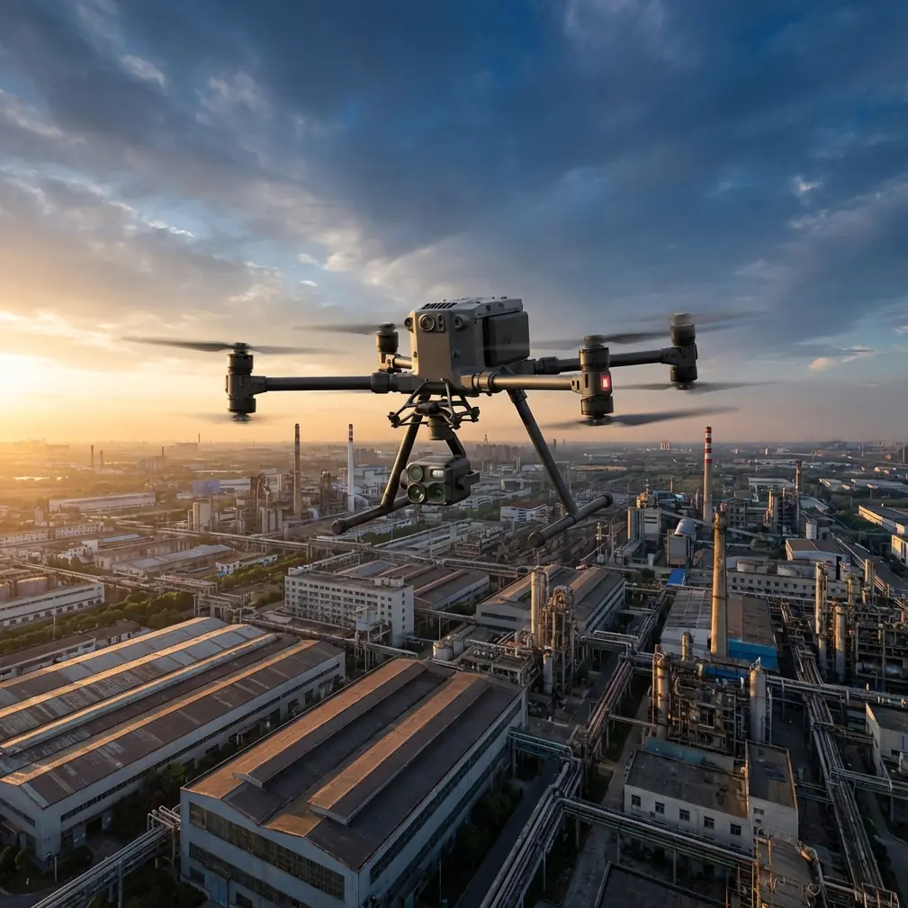
Urban solar sites look simple from the road. Long rows of panels. Clean geometry. Predictable access. In the air, they are anything but simple.
A solar farm inside or near a built-up area creates the kind of flying environment that exposes weak planning fast. You have reflective surfaces everywhere, patchy background lighting at dawn or dusk, RF congestion from surrounding infrastructure, and narrow operating windows when the site is active but not crowded with maintenance teams. If your aircraft is a Matrice 4, the mission is not just about getting attractive footage. It is about building a repeatable workflow that holds up when the conditions stop being cooperative.
I want to focus on one angle that is usually skipped in generic drone articles: what traditional aircraft electrical design can teach us about using Matrice 4 more intelligently for solar farm filming. That may sound academic. It is not. Two reference points matter here.
First, aircraft lighting design standards emphasize that external lighting must maintain adequate brightness even when ambient light is poor, so the aircraft can operate safely during takeoff, landing, taxiing, and collision avoidance. They also specify that light color must comply with recognized standards and that filters or covers should not visibly deform or fade over their service life, because that would reduce light intensity. Second, aircraft wiring documentation standards insist on something equally practical: logic diagrams must be consistent, component references must be traceable, and you should never mix symbol systems on the same diagram because confusion in documentation becomes confusion in operation.
Those ideas translate surprisingly well to Matrice 4 work over urban solar assets.
The urban solar farm problem is really a visibility problem
When operators talk about filming solar farms, they usually jump straight to camera payloads, thermal signature capture, or photogrammetry outputs. Those matter, especially when a client wants both cinematic footage and a defect-detection layer in the same visit. But for actual field performance, visibility comes first.
The aircraft handbook material I reviewed makes a blunt point: external lighting has to remain effective in low outside illumination and must support safe movement while reducing collision risk. For a Matrice 4 operator, the operational meaning is clear. Early-morning and late-afternoon flights over solar arrays are attractive because panel reflections are softer and thermal contrast can be stronger. They are also the moments when visual acquisition of the aircraft becomes more difficult against mixed urban backgrounds.
That means your preflight should include more than battery percentages and obstacle sensing checks. Look at the aircraft’s external lighting condition the same way a pilot would evaluate a light assembly on a larger aircraft. If a lens cover is scratched, yellowed, warped, or dirty, it is not cosmetic. The source text specifically warns that lamp covers or filters must not show obvious deformation or fading over their life, and must not noticeably reduce light output. On a drone job, that translates into visual conspicuity. In an urban perimeter with cranes, rooftops, utility poles, and service roads, poor lighting performance can make it harder for visual observers to maintain line of sight and harder for nearby workers to notice the aircraft’s position.
That is a safety issue, but it also affects shot quality. If your team loses confidence in aircraft visibility, everyone gets conservative. You pull back on dynamic moves. You shorten runs. You avoid lower-angle passes along panel rows that would otherwise produce the strongest reveal footage. Clean external lights support more confident operations, especially under flat dawn light.
Glare is not just a camera problem
The same aircraft design source also states that external lights should be installed or shielded so their intensity distribution meets requirements without creating direct or reflected glare that interferes with crew vision. That line could have been written for urban solar work.
Solar farms are giant glare engines. Even when you are not filming at high noon, panel surfaces can throw unpredictable reflections into the pilot’s viewing angle, into the observer’s line of sight, and back into the camera. Operators usually think about ND filters and camera angle adjustments. They should also think about aircraft positioning relative to their own visibility.
With Matrice 4, I treat reflective-row flights as a geometry exercise. Stand where your own visual line to the aircraft is least likely to align with the strongest panel reflection. Then orient the controller antennas deliberately rather than casually. In dense urban RF environments, range is not only about transmission power. It is about preserving a clean path between aircraft and controller while avoiding your own body, vehicle, or metal structures from becoming a signal obstacle.
A simple antenna rule helps: do not point the antenna tips directly at the aircraft. Broadside orientation is usually stronger because that is where the antenna pattern performs better. Keep the controller chest-high, angle the antennas so their flat sides face the aircraft’s expected corridor, and rotate your own stance as the drone tracks across the site. On long lateral passes, especially near substations or rooftop-edge infrastructure, small body movements can materially improve link consistency.
That matters more if you are relying on O3 transmission in a cluttered spectrum environment. Urban solar sites often sit near industrial estates, telecom installations, or commercial roofs full of emitters. Good antenna discipline is one of the cheapest performance gains available.
Why documentation discipline belongs in a drone workflow
The second reference document deals with electrical drawings, but its message is operational gold for Matrice 4 crews. It says that systems with logic devices should have logic diagrams, signal characteristics should be shown clearly, components should be labeled by type and location, and symbol systems should remain consistent on a given sheet. In plain English: if you want reliable execution, your system map cannot be vague.
For a solar farm filming mission, your “logic diagram” is the workflow that connects aircraft configuration, payload mode, transmission plan, batteries, and output requirements. Most crews keep this in their heads. That works until the mission changes halfway through.
A better approach is to create a one-page mission logic sheet before arrival. Mine has five branches:
- Primary deliverable — cinematic video, inspection thermal layer, orthomosaic, or all three.
- Flight mode sequence — manual establishing shots first, then thermal grid, then photogrammetry, or another order based on light.
- Battery logic — where hot-swap batteries happen, what gets paused, and what data checks are mandatory at each change.
- Link discipline — pilot position A, alternate position B, observer sector boundaries, and antenna orientation notes.
- Data security — storage handling and encrypted transfer steps if the client requires controlled asset data.
This is where the reference to clear component labels and non-mixed symbols really pays off. If one pilot uses one naming convention, the payload operator uses another, and the editor uses a third, handoff errors multiply. For example, a thermal pass labeled “Block C east string scan” should not become “row 3 thermal maybe” in post. Traceability is not bureaucracy. It is how you avoid re-flying a site because nobody can tell what was actually captured.
The handbook also mentions that incomplete depictions of components on system schematics should still reference related circuit numbers and a master diagram. The drone equivalent is straightforward: every partial output should point back to a master mission map. Every video clip set, thermal batch, and photogrammetry block should trace to one site grid. If you are using GCPs for higher mapping fidelity, tie them to that same master reference rather than treating them as a separate survey artifact.
Thermal and photogrammetry on the same visit: sequencing matters
Matrice 4 operators are often asked to do too much in one deployment. Establishing footage. Thermal signature screening. A photogrammetry pass for asset records. Sometimes a close visual sweep of combiner boxes or cable runs. The aircraft can handle multi-role work, but the site conditions decide the right order.
Urban solar filming has a timing conflict. Thermal inspection often benefits from a window when panel-level anomalies separate cleanly. Cinematic footage tends to look best when the site has dimensional light, not a harsh overhead wash. Photogrammetry wants consistent overlap and stable exposure. If you try to satisfy all three goals without a sequence plan, one of them will be compromised.
My usual order is:
- Quick establishing video if the light is working and site traffic is low
- Thermal capture while the contrast is still useful
- Photogrammetry block once the site is visually stable and shadows are predictable
- Detail pickups after the core datasets are secured
This sequencing reduces the risk that creative filming burns the best thermal window. It also aligns with the logic-driven discipline from the reference material: define the system state, signal flow, and output dependencies before takeoff instead of improvising in the air.
Lighting standards also reshape nighttime edge cases
Most commercial solar filming is daytime work, but there are edge cases. Some operators capture dawn startup visuals, maintenance access at low light, or perimeter context shots when ambient illumination is weak. That is where the older aircraft lighting criteria become newly relevant.
The source document says external lighting should support safe operations even when outside illumination is insufficient. It also notes that standard arrangements usually include navigation lights, landing or taxi lights, and anti-collision strobes, while mission-specific aircraft may add other lights depending on purpose. The drone parallel is not that Matrice 4 suddenly becomes a manned aircraft. It is that you should evaluate whether your aircraft’s visibility aids are actually supporting the mission profile you intend to fly.
If the site has bright urban spill on one side and a dark service corridor on the other, the aircraft can disappear visually as it crosses contrast bands. Anti-collision lighting and aircraft orientation become more significant than many crews realize. Before any low-light operation, do a short hover at expected working distance and confirm how visible the aircraft really is from pilot and observer positions. What looks obvious 10 meters away can be surprisingly weak over a field of dark glass.
AES-256 and asset sensitivity
Solar farms are infrastructure assets. In urban settings, clients often care less about “pretty drone footage” than about controlling what happens to inspection imagery, string layouts, roof adjacency, and substation context. If your Matrice 4 workflow includes AES-256 protected data handling, that should be part of the mission design, not an afterthought after capture.
This links back to the documentation standard again. Label what was captured. Record where it came from. Define handoff paths. Keep the chain clean. Security is not only encryption strength. It is process clarity.
If a facilities manager wants a practical checklist for urban solar documentation and mission setup, I usually point them to a direct project discussion channel so the flight logic, deliverables, and site constraints are defined before the team arrives.
BVLOS talk is often a distraction on urban sites
BVLOS comes up in almost every serious Matrice 4 conversation now, but for urban solar farms it is often the wrong centerpiece. The harder problem is not legal flight distance. It is sustaining stable control, safe visibility, and disciplined data capture in a reflective, RF-noisy environment with people and structures nearby.
Even when a site footprint is large, I prefer to solve the mission with better pilot positioning, planned handover points if regulations allow, and careful antenna management before framing the whole task as a BVLOS-style challenge. On many urban jobs, poor stance and bad controller orientation cost more usable range than the aircraft itself.
What separates a smooth Matrice 4 solar job from a frustrating one
Not the headline specs. Not the marketing language. Usually it is the boring stuff done properly.
Clean and undistorted external light covers, because low-light visibility matters more than people admit.
Intentional antenna positioning, because O3 link quality depends on geometry as much as hardware.
A mission logic sheet, because thermal, video, and photogrammetry compete for the same time window.
Consistent file and grid references, because traceability is what makes the data usable after the flight.
Disciplined hot-swap battery workflow, because continuity errors happen on the ground, not in the air.
The old aircraft design references I used here were not written for drones, and certainly not for Matrice 4 filming solar farms in a city-adjacent environment. Still, the principles hold. Lighting has to remain effective. Glare must be controlled. Equipment placement affects real-world function. Documentation must be consistent enough that no one guesses what a system state means.
That is the difference between getting a few attractive clips and delivering an operation that a commercial solar client can trust the second time, not just the first.
Ready for your own Matrice 4? Contact our team for expert consultation.