Matrice 4 in Windy Solar Farms: A Field-First Case Study
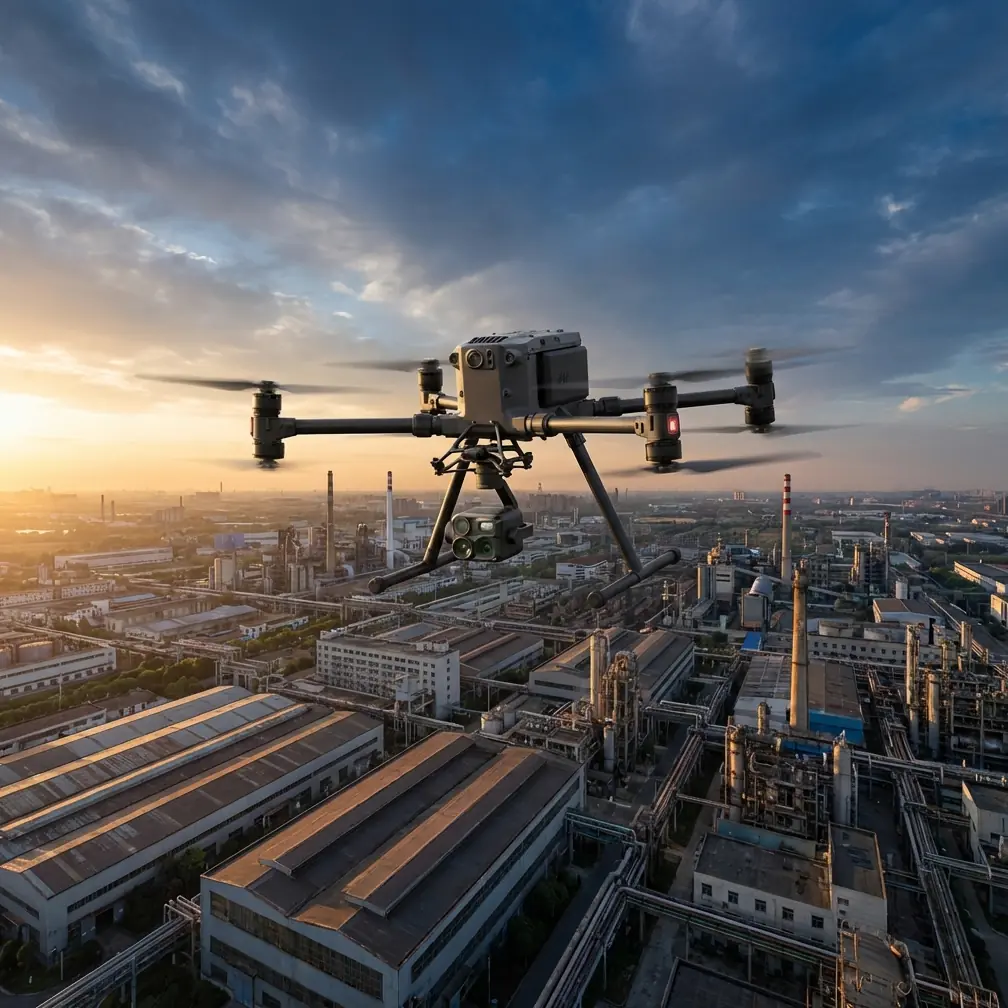
Matrice 4 in Windy Solar Farms: A Field-First Case Study on Stability, Structure, and Smarter Flight Altitude
META: Expert case study on using Matrice 4 for filming and inspecting windy solar farms, with practical guidance on flight altitude, structural load thinking, transmission reliability, and mission planning.
Wind changes everything over a solar farm.
On paper, utility-scale PV sites look simple: long rows, repeated geometry, open air, easy visibility. In practice, they are one of the more deceptive environments to film well. The terrain often channels gusts. Heat shimmer can distort detail by midday. Repeating panel patterns challenge autofocus and composition. And if you are trying to produce both cinematic footage and useful inspection-grade imagery in one mission, small planning errors get exposed fast.
That is exactly where the Matrice 4 conversation becomes interesting.
Not because the aircraft exists in a vacuum, but because windy solar farm work puts pressure on the parts of a drone operation that actually matter: structural stability, load path discipline, transmission confidence, battery workflow, and altitude selection that fits both image quality and air movement. For an operator filming a solar farm in wind, the best mission is rarely the one flown lowest or fastest. It is the one that respects how the aircraft and its payload are being loaded through the airframe while still delivering clean data.
Why wind over solar fields is not just “more resistance”
Most drone discussions reduce wind to one line item: can the aircraft hold position?
That is too shallow for real commercial work.
A better way to think about a drone in gusty solar farm conditions is through structural load transfer. One of the reference engineering texts here describes the fuselage of an aircraft as a beam supported at a major junction point, with forces from internal mass, surface aerodynamics, and external components all being carried through the load-bearing structure until they are balanced. Another detail from that same source breaks the structure into skin, frames, stringers, beams, and partitions, each with a role in taking shear, torsion, or longitudinal force.
That matters operationally even if you are not designing the Matrice 4.
When your aircraft gets hit by uneven lateral gusts crossing panel rows, the challenge is not simply thrust compensation. The drone’s structure, gimbal interface, and propulsion system are all participating in how those forces are absorbed and corrected. The engineering principle is simple: loads do not disappear; they travel. In drone terms, that means a gust seen in footage is often the visible result of a load path event, not just a pilot input issue.
For solar farm filming, this explains why two flights at the same location can look radically different even with the same camera settings. If one mission is flown at an altitude where airflow is turbulent from panel-induced thermal effects and terrain deflection, the aircraft may still remain safely controllable while producing micro-corrections that degrade visual smoothness and mapping consistency. The airframe may be doing its job perfectly, yet the output still suffers.
The best altitude is usually not the dramatic one
Let’s get practical.
If I were planning a Matrice 4 mission over a windy solar farm, I would not start by asking how low I can fly for dramatic parallax. I would start by finding the lowest altitude that is outside the messiest near-surface air while still preserving the ground sample detail needed for the deliverable.
For this scenario, a highly effective working band is often around 35 to 60 meters AGL for general filming passes and visual inspection coverage, then adjusted based on lens choice, row spacing, and wind profile. That range is high enough to reduce some of the rotor-to-gust overreaction you often feel close to the panel field, yet still low enough to preserve structure in module rows, inverter pads, access lanes, and substation context.
Below roughly that zone, three things often start working against you:
- Mechanical turbulence from terrain, fencing, service buildings, and even the repeating geometry of panel arrays.
- Thermal signature distortion, especially later in the day, when heated surfaces create uneven rising air and visible shimmer.
- Exaggerated visual instability, where small aircraft corrections appear larger because the camera is close to high-contrast lines.
Higher is not automatically better either. Once you push too far upward, you can reduce visual richness, flatten row geometry, and make thermal or visual anomalies harder to contextualize. For photogrammetry, excessive altitude can also dilute the practical value of your overlap if your target is small defect context rather than broad topographic mapping.
So the “optimal” altitude is not a fixed number. It is a compromise between air quality, image geometry, and mission objective. But if you need a starting point in windy solar farm filming with Matrice 4, 35 to 60 meters is where I would test first, then tune from there.
Wind planning should follow dynamics, not hope
The helicopter reference in the source material adds a second useful lesson. It discusses coupled motion and makes a point that instability is not always solved by simply adding more damping elsewhere. In one example, increasing damping in other components did little to fix the problematic mode, while broader system behavior still depended on how coupled dynamics interacted. The text even formalizes the motion as a unified system equation, M()X + C()X + K(X = 0, which is classic shorthand for mass, damping, and stiffness shaping the response together.
You do not need to solve differential equations in the field to benefit from that logic.
The takeaway for Matrice 4 operations is that wind issues are system issues. If your footage is unstable, the answer is not always “slow down more” or “raise ISO and shorten exposure” or “trust stabilization.” Sometimes the real fix is changing the altitude band, the flight direction relative to panel rows, or the leg spacing so the aircraft is not repeatedly entering the same coupled disturbance pattern.
On solar farms, I’ve seen the best results come from three adjustments:
1. Fly diagonal reconnaissance first
Before a formal run, make one high-confidence diagonal pass across the site. This shows where gusts are being funneled by topography, embankments, or electrical infrastructure. Wind rarely behaves uniformly across a large solar field.
2. Align primary legs with output priority
If the priority is cinematic continuity, fly with the row geometry in a way that minimizes visible side-correction. If the priority is inspection or photogrammetry, choose the path that protects overlap consistency and panel recognition first.
3. Separate film passes from data passes
Trying to create hero footage and mapping-grade captures in one profile usually degrades both. Use one altitude and speed strategy for visual storytelling, another for thermal signature review or photogrammetry with GCP support.
Matrice 4 is strongest when the mission is integrated
A windy solar farm mission is a good test of whether the aircraft is being used as a platform or just as a camera holder.
If your Matrice 4 workflow includes O3 transmission, that matters here because wide, reflective, open sites can be deceptively difficult from an operational confidence standpoint. Solar farms are not urban canyons, but long distances, uniform visual textures, and occasional infrastructure clutter can make orientation and signal discipline more critical than people expect. Reliable downlink quality directly affects how confidently you can hold framing during gust transitions and decide whether to continue or abort a pass.
If your operation requires secure handling of site imagery, AES-256 is not a throwaway specification either. Utility operators and EPC stakeholders increasingly care about infrastructure media control, especially when footage reveals plant layout, electrical equipment positioning, or maintenance status. On large commercial energy sites, data governance is part of professionalism, not an afterthought.
Then there is endurance workflow. Hot-swap batteries are especially useful on solar farms because these sites punish downtime. They are large, exposed, and often accessed under narrow weather windows. When the wind softens for twenty minutes, you do not want a slow battery transition to waste your cleanest air of the day. Hot-swap capability is not about convenience; it is about preserving mission continuity during the exact moments when atmospheric conditions improve.
And if you are operating in a framework where BVLOS planning is relevant, that raises the value of route discipline even further. On long linear or expansive sites, every segment of the mission has to be designed with stronger predictability in aircraft behavior, link management, and data capture logic. Wind makes sloppy route design expensive.
Thermal work over solar farms needs its own clock
Many operators try to combine visual filming and thermal capture at whatever time is most convenient.
That usually compromises the thermal side.
For solar farm work, thermal signature interpretation depends heavily on surface heating patterns, irradiance, and environmental stability. Wind can both help and hinder. A steady moderate airflow may improve consistency across rows by reducing some localized heat buildup, while variable gusting can create uneven thermal behavior and make interpretation less straightforward.
The mission design question for Matrice 4 is not just whether the thermal sensor sees a hotspot. It is whether the flight profile lets you distinguish between a genuine module or connector issue and an environmental artifact. If the aircraft is flying too low through unstable heated air, the image may be more vulnerable to shimmer and micro-instability. If it is too high, anomaly context can get weaker. Again, that mid-altitude discipline matters.
When combining thermal with visual and photogrammetry outputs, I recommend thinking in layers:
- Visual establishing pass at a stable mid altitude
- Thermal inspection pass during the site’s appropriate thermal window
- Photogrammetry grid with overlap designed around final deliverable and any required GCP layout
That sequence reduces confusion later when stakeholders ask why a thermal anomaly does not line up neatly with the cinematic clip or the orthomosaic.
Ground control still matters in repetitive landscapes
Solar farms create one of the most repetitive visual environments you can map. Row after row of near-identical surfaces can fool operators into assuming automation alone will carry the survey.
It will not.
If the deliverable includes precise photogrammetry, GCP planning still has real value. Repetition in panel geometry can reduce the visual distinctiveness that reconstruction workflows prefer. Wind adds another variable by nudging aircraft attitude corrections during capture. Ground control gives you a practical anchor against cumulative drift and ambiguity in a site where many image sections can look nearly interchangeable.
This is one of those details that separates a pretty map from an operationally trusted one.
A field note on filming style in gusts
Here is the biggest filming mistake I see over solar sites: operators trying to force cinematic movement when the air is clearly asking for simpler geometry.
In wind, the Matrice 4 usually produces cleaner, more usable solar farm footage when you favor:
- longer holds,
- steadier lateral moves,
- moderate yaw rates,
- fewer stacked motion axes at once.
Why? Because each additional movement axis asks the aircraft to solve more correction problems while the environment is already feeding it disturbances. Smooth output is easier when the flight path is structurally honest.
That may sound obvious, but it echoes the structural logic from the aircraft reference. Thin skin, frames, and longitudinal members each do their share because the whole system is organized around carrying load intelligently. Good drone flying in wind follows the same philosophy. Don’t fight every force with style. Distribute the problem through smarter planning.
When the site team asks, “Can you still fly today?”
The right answer is not yes or no. It is, “What is the output standard today?”
If the client only needs broad progress visuals, the Matrice 4 may still deliver in wind that would be unacceptable for thermal diagnosis or high-accuracy photogrammetry. If the goal is a mixed package—cinematic footage, thermal review, and orthomosaic support—you may need to split the mission by time block or defer one component.
That is usually the conversation that earns trust.
If you need a second set of eyes on mission design for a windy solar site, you can message a Matrice 4 flight planning specialist here and compare your route, altitude band, and payload priorities before mobilizing.
What really makes Matrice 4 effective here
Not hype. Not specs on a brochure.
It is the way the platform can fit into a disciplined workflow where wind, data integrity, and site scale are treated as connected variables. The engineering references behind this discussion point to two enduring truths:
First, structural systems work because loads are transmitted through defined paths, not because any one component magically “absorbs” complexity. That is directly relevant to drone operations in gusty conditions. Your aircraft, gimbal, route, speed, and altitude are all part of the response.
Second, coupled motion problems are rarely solved by one blunt adjustment. Increasing damping somewhere else in the system does not always remove the unstable behavior you care about. In field terms: if your solar farm footage is unstable, don’t just slow down and hope. Rework the mission geometry.
For Matrice 4 pilots filming solar farms in wind, that means choosing an altitude band with purpose, usually beginning around 35 to 60 meters AGL, separating cinematic and analytical tasks, protecting transmission reliability, and using tools like hot-swap batteries and GCP-backed planning where they actually improve outcomes.
That is how you get footage that looks controlled and data that stands up after the flight.
Ready for your own Matrice 4? Contact our team for expert consultation.