Matrice 4 in Steep Vineyards: A Field Report on What
Matrice 4 in Steep Vineyards: A Field Report on What Actually Changes in Mountain Filming
META: Expert field report on using Matrice 4 for filming vineyards in mountain terrain, with practical insights on transmission, battery workflow, thermal awareness, and photogrammetry.
I’ve filmed vineyards on flat estates, coastal hills, and terraces so steep that carrying a tripod felt like a safety drill. The mountain sites are the ones that expose every weakness in a drone platform. Light shifts fast. Wind rolls over ridgelines instead of arriving cleanly. Signal paths get interrupted by slope geometry. And if you are trying to capture footage that is not just cinematic but operationally useful for growers, the usual “fly a few passes at golden hour” approach falls apart.
That is where the Matrice 4 starts to make sense.
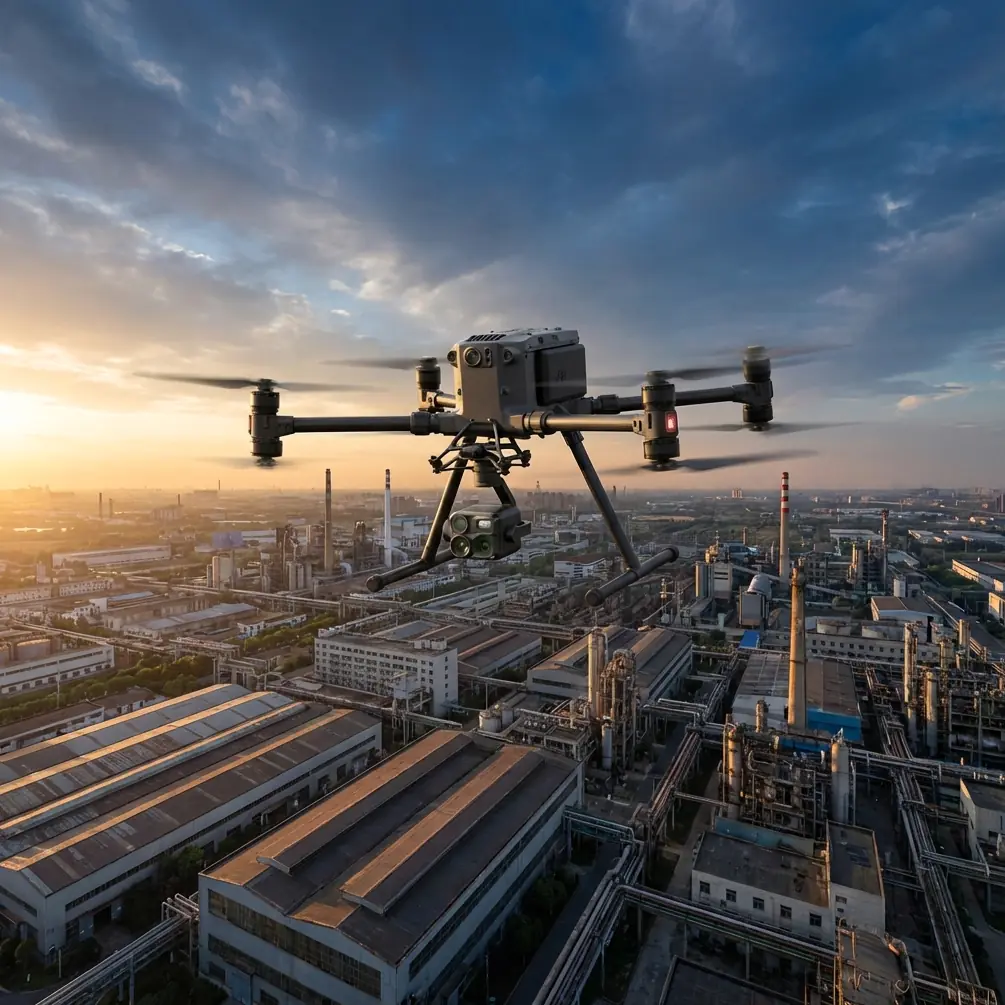
Not because it is a buzzworthy airframe. Because in mountainous vineyard work, the bottlenecks are brutally practical: keeping a stable transmission link when you drop behind a contour, managing battery swaps without losing the window of good light, and collecting imagery that can pull double duty for both film and site analysis. The Matrice 4 addresses those points in ways that matter in the field, especially when the assignment is more than pretty footage.
The problem mountain vineyards create
A mountain vineyard is rarely one continuous block. It is usually broken into terraces, access tracks, retaining walls, service roads, drainage channels, and parcels angled differently against the sun. From the pilot’s perspective, this means you are never really working in one environment. Every turn of the slope creates a new one.
A few years ago, on a ridge site with narrow vine rows and scattered tree cover, the hardest part was not image quality. It was continuity. We could get one excellent reveal shot over the top of a parcel, then lose momentum because the aircraft had to be repositioned for safer line management, batteries needed changing, and the transmission link became unreliable as soon as the slope dropped away. What should have been a smooth half-hour sequence turned into fragmented short flights.
That kind of day changes how you evaluate a platform. Resolution and lens options matter, of course, but workflow matters more. If the aircraft cannot hold together the mission from one parcel to the next, you spend more time recovering than creating.
Why O3 transmission matters more in vineyards than spec sheets suggest
One of the most useful details in the Matrice 4 conversation is O3 transmission. On paper, transmission systems often get treated as a background feature, almost an assumed baseline. In mountain vineyards, it is not background. It determines whether the job remains controlled and efficient.
The issue is not simply distance. It is obstruction. Vineyards in mountain terrain create partial signal shadowing as soon as the aircraft moves below a lip, behind a stand of trees, or along a folded terrace line. A stronger, more resilient transmission system helps preserve command confidence when the aircraft is navigating those terrain transitions.
Operationally, this changes two things.
First, it reduces the need to constantly relocate the pilot position just to maintain a cleaner link. That sounds minor until you are carrying cases up a rocky service road and trying to stay on schedule between wind peaks.
Second, it allows more deliberate camera movement. When a pilot trusts the link, flights become smoother and more intentional. You can hold a longer tracking pass along a contour row or maintain a measured reveal over a retaining wall instead of flying defensively and cutting shots short.
For vineyard filmmakers, that translates directly into footage quality. For vineyard managers who also want useful visual records of canopy uniformity, row alignment, access condition, or drainage behavior, it means fewer gaps in coverage.
AES-256 is not just an IT footnote
Another detail that gets overlooked too often is AES-256. People hear encryption and assume it is relevant only to high-security institutions. In commercial vineyard operations, it has a different kind of value.
Many mountain vineyards are private estates or contract-managed properties with sensitive data attached to them: parcel development plans, irrigation layouts, disease management observations, labor logistics, and documentation tied to export standards. If your drone operation involves not just promotional filming but also site mapping, thermal review, or regular progress documentation, secure data handling becomes part of professional practice.
AES-256 matters because drone flights increasingly generate more than media. They create operational records. When a viticulture team is using aerial outputs for internal planning, the expectation is not simply “capture good images.” It is “capture them responsibly.”
That makes the Matrice 4 better suited to serious commercial operators than aircraft evaluated only through a content-creator lens.
The hidden value of hot-swap batteries on a slope
In a flat open field, battery changes are a routine pause. In a mountain vineyard, they can break the whole rhythm of the day.
The terrain itself slows every hand movement. You are often standing on uneven ground, working out of a compact landing zone, with changing wind and little room for delays. If you miss a light interval over one terrace, you may not get the same texture again for another hour. Shadows move quickly across vine rows, especially when hillsides face slightly different directions.
This is where hot-swap batteries become one of those features that sounds technical until you use it in a difficult environment. The ability to change power sources without shutting down the entire operational flow reduces dead time between sorties. That matters when you are trying to stitch together a continuous visual narrative of a property.
For mountain vineyard filming, continuity is everything. A sequence showing lower terraces, a mid-slope climb, and a crest-line reveal only works if the visual conditions remain coherent. Fast turnaround between flights helps preserve that coherence.
It also lowers fatigue. Pilots and crews make better decisions when the workflow is not constantly resetting. In demanding terrain, that is not a luxury. It is risk reduction.
Thermal signature work in vineyards is more useful than many crews realize
The phrase “thermal signature” tends to get misread as something niche. In vineyard operations, it can be quietly valuable.
I am not talking about dramatic heat maps for their own sake. I mean practical detection of variation: differences in vine vigor expression, irrigation anomalies, water stress patterns, and temperature-related inconsistencies across blocks that appear uniform from eye level. On a mountain site, these variations can be amplified by slope orientation, altitude, drainage, and solar exposure.
When a drone platform supports thermal-aware workflows, the same mission day can produce both compelling visual assets and decision-support material. That combination is powerful for vineyard owners who need media for branding but also want to understand what the property is doing physically across different sections.
In steep terrain, thermal interpretation becomes especially relevant around transition zones. A parcel that sits just below a rock face or beside a drainage cut may behave differently from the rows above it. From the ground, those differences are easy to miss or underestimate. From the air, thermal signature patterns can reveal where follow-up inspection should happen.
The operational significance is simple: one flight can do more than one job.
Photogrammetry in vineyards is not only for survey teams
Photogrammetry often gets pushed into the “mapping specialist” category, but mountain vineyards are one of the clearest examples of why filmmakers and operations teams should care about it too.
If you are documenting a property with elevation change, retaining structures, access roads, row geometry, and expansion areas, photogrammetry turns imagery into a spatial asset. That can support terrain models, drainage planning, access route review, erosion monitoring, and visual planning for future planting or infrastructure work.
Add GCP workflow into the mix, and the outputs become more reliable for teams that need stronger positional consistency. Ground Control Points are not glamorous, but they matter when a property owner wants repeatable comparisons over time rather than a one-off visual impression.
This is where the Matrice 4 fits well into a broader vineyard workflow. A platform used in the morning for film capture can support structured image collection later in the day for photogrammetry. That flexibility is especially valuable on mountain sites where access is hard and each field visit needs to produce as much usable output as possible.
For growers and consultants, the significance is practical. Better terrain understanding supports smarter movement of equipment, more informed irrigation planning, and clearer records of how the site evolves season to season.
BVLOS discussions should be grounded in real vineyard logistics
BVLOS is one of those terms that gets thrown around with more enthusiasm than context. In mountain vineyard work, the real issue is not ambition. It is whether longer-route operations can be handled within the applicable regulatory framework, site conditions, and mission objectives.
The reason the term belongs in a Matrice 4 discussion is that vineyard estates in hilly regions can cover fragmented, inaccessible land. A drone mission may need to connect separated blocks divided by roads, tree belts, ravines, or contour changes. Any conversation about efficient coverage eventually touches on beyond visual line of sight planning, or at least BVLOS-adjacent operational thinking.
But the point is not to stretch flights casually. The point is to use a platform capable of supporting serious operational planning when regulations, risk controls, and site permissions align. In the vineyard world, that means reducing repeated hikes between launch points, improving coverage efficiency across isolated parcels, and making aerial documentation more viable for larger estates.
Used responsibly, that changes the economics of time on site. It is not flashy. It is simply smarter field logistics.
What changed for me when using this class of platform
The biggest difference was not one dramatic flight. It was the removal of small frictions that used to drain mountain assignments.
I stopped planning around the expectation of broken continuity. I could think in longer sequences. I could assign the same aircraft to visual storytelling, thermal review, and image capture for photogrammetry without feeling like I was forcing a tool beyond its natural role. The job became less about managing limitations and more about choosing the right output for each parcel.
That matters in vineyards because the client is often not one person. You may be answering to a property owner, a marketing lead, an operations manager, and an agronomy consultant in the same project. One wants atmosphere. One wants accuracy. One wants speed. One wants repeatability. A useful drone platform in this environment needs to satisfy all four at least reasonably well.
The Matrice 4 sits closer to that requirement than many aircraft that are either too cinema-focused or too narrowly industrial in their workflow.
Practical filming tips for mountain vineyards with Matrice 4
A few field-tested habits make a real difference:
Start with the highest parcel if wind is expected to build. Ridge exposure usually gets worse, not better.
Use your first battery cycle to establish terrain behavior, not to chase hero shots. Watch where the signal environment changes along the slope and where shadows fall across the rows.
If the site has mixed purposes, capture your clean cinematic passes first, then move into structured imagery for photogrammetry while the light becomes less flattering for film. That preserves the strongest visual results without wasting the rest of the day.
If thermal signature work is part of the mission, coordinate with the vineyard team about irrigation timing and recent weather. Thermal data without context can mislead.
Where higher positional confidence matters, build a GCP plan before arriving. On mountain properties, “we’ll place them when we get there” often turns into a slow scramble.
And if you are working through a complex property and want help matching the aircraft setup to that terrain, I usually suggest sending the mission outline first via direct WhatsApp project notes. It saves a surprising amount of back-and-forth.
The real takeaway
Mountain vineyards reward precision and punish improvisation. They are visually beautiful, but from a drone operator’s standpoint, they are demanding work sites where transmission resilience, secure data handling, efficient battery management, thermal awareness, and mapping capability all matter at once.
That is why the Matrice 4 deserves to be discussed as more than a camera platform. In this setting, O3 transmission is about maintaining control across broken terrain. AES-256 is about protecting operational imagery and site records. Hot-swap batteries preserve continuity when light and slope make every pause expensive. Thermal signature workflows help reveal differences between blocks that look similar from the ground. Photogrammetry with GCP support turns a filming day into a spatial documentation day.
For vineyard teams in mountainous regions, that combination is not abstract. It is exactly what makes the difference between a drone visit that produces attractive clips and one that produces lasting value.
Ready for your own Matrice 4? Contact our team for expert consultation.