Inspecting Urban Construction Sites with Matrice 4
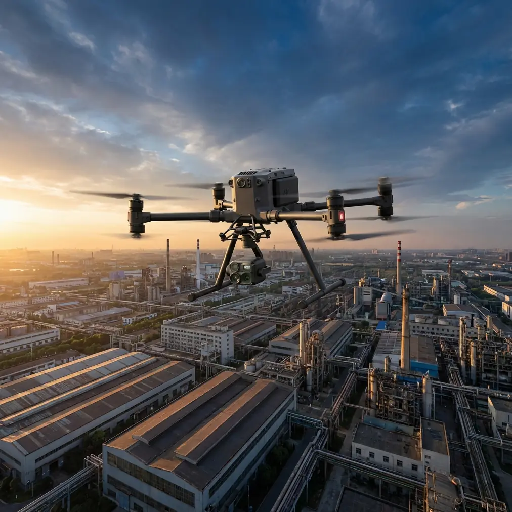
Inspecting Urban Construction Sites with Matrice 4: A Field Report from the Hard Jobs
META: A practical field report on using Matrice 4 for urban construction inspection, with lessons from high-altitude heavy-lift testing, GPS integrity, barometric accuracy, thermal workflows, and safer data capture.
A few years ago, one of the toughest construction inspections I handled had nothing to do with distance. The site was right in the city. Tower cranes, reflective glass, half-finished concrete cores, GPS bounce, narrow takeoff zones, and a project team that wanted answers before the afternoon coordination meeting. We had the aircraft. We had the pilot. What we did not have was much tolerance for drift, bad altitude references, or wasted battery cycles.
That is why the most interesting way to think about Matrice 4 is not as a spec-sheet exercise. It is as a response to the exact headaches that appear on dense urban jobsites: unstable air around structures, questionable GNSS quality near steel, repeated close-range orbits, pressure to document progress fast, and the need to trust every dataset later when someone compares this week’s facade scan against last month’s punch-list images.
The recent high-altitude heavy-lift test by Xi’an Tianyi Technology Group offers a useful lens for this. On paper, that aircraft was not a Matrice 4. But the operating lesson translates directly. At 5,380 meters, in air density reported at roughly 60% of sea-level conditions, the JDY-100B lifted a 30 kg suspended load, held stable, flew for 15 minutes, and landed accurately. That matters because it isolates a truth many site teams miss: when the air gets thin, margins shrink. Stability is no longer abstract. It becomes the difference between clean data and an unusable mission.
Urban construction sites create their own version of margin compression. Not from altitude, usually, but from interference, wind tunneling between buildings, thermal contrast on facades, and poor staging discipline on the ground. A platform like Matrice 4 earns its place when it keeps producing reliable inspection data despite those constraints.
The lesson from extreme flight testing: stability is what buys usable inspection data
The Tibet record flight did more than set a headline. It demonstrated controlled hover under punishing environmental conditions. The detail that stands out to me is not just the payload claim or the 221 kg maximum takeoff weight of the test aircraft. It is the stable suspended-load behavior in thin air. Any experienced pilot knows a swinging load tells you immediately what the control loop cannot tame.
On an urban construction inspection, your “load” is often the sensor task itself. A thermal camera trying to identify envelope leakage. A zoom payload checking bolt conditions on a crane tie-in. A photogrammetry run that depends on consistent overlap and predictable aircraft motion. If the aircraft cannot hold its line cleanly, your thermal signature smears, your orthomosaic struggles, and your comparison set loses value.
This is where Matrice 4 fits the real-world workflow. On city sites, I care less about broad marketing claims and more about whether the aircraft lets me fly a repeatable route along elevation changes, around parapets, and under shifting wind with confidence. Repeatability is money. It means less reflight, fewer arguments with project managers, and cleaner reports for engineers and owners.
Why altitude logic and pressure logic still matter in the city
Another detail from the reference material seems small until you’ve had a bad day: the GND_ALT_OFFSET parameter in the ArduCopter document, which corrects the barometer’s initial zero point. That is a technical footnote with huge operational significance.
Construction inspections in urban environments often begin from imperfect launch locations. Maybe you launch from a podium deck, a temporary site office roof, or a loading bay tucked between structures. If your altitude reference is wrong from the start, every later observation inherits the error. A crack photo on level 18 may still look sharp, but if your vertical metadata is off, comparing defect progression over time becomes messy. For facade work, roof drainage checks, and progress verification, small altitude inconsistencies stack up quickly.
Matrice 4 crews who understand this tend to work differently. They do not just launch and hope. They establish a consistent mission origin, document takeoff elevation, confirm obstacle-clearance assumptions, and keep a disciplined flight log when repeating missions. In practical terms, that turns a drone from a camera in the sky into a measurement tool.
The same goes for GND_TEMP 15.28128, the ground temperature preset noted in the source material. Again, it looks obscure. It is not. Thermal inspection is sensitive to environmental assumptions. If you are using Matrice 4 to identify moisture intrusion, insulation voids, heat leakage, or electrical hotspots on temporary power systems, ambient conditions shape interpretation. Thermal signature work is not simply “hot equals bad.” Ground temperature, solar loading, surface material, and time of day all influence what the sensor shows. Teams that ignore those variables generate colorful images. Teams that account for them generate decisions.
GPS integrity is not optional near cranes and steel
If I had to name the most common urban construction drone mistake, it would be overconfidence in GNSS. The ArduCopter reference includes several parameters worth paying attention to: GPS_HDOP_GOOD 200, GPSGLITCH_ENABLE 1, GPSGLITCH_ACCEL 1000 cm/s/s, and GPSGLITCH_RADIUS 200 cm.
These are not random controller settings. They reflect a basic flight reality: positioning data can degrade or become unreliable, and the flight system needs logic to recognize and contain the damage.
That is exactly what happens around steel structures, tower cranes, temporary generators, reflective curtain wall, and cluttered RF environments. On-site, this usually shows up in subtler ways than people expect. Not a dramatic flyaway. More often, it is a hesitant hold, a brief mismatch between expected and displayed position, or an orbit that does not close as neatly as planned. For inspection work, that is enough to compromise a dataset.
With Matrice 4, this is where disciplined operators separate themselves from casual users. They check satellite health before takeoff. They compare map position with visual reference. They use conservative standoff distances around GPS-hostile features. They lean on robust transmission links such as O3 transmission where available in the workflow, not because long range is glamorous, but because stable command and video links help preserve decision-making under interference. They also secure sensitive project imagery using AES-256 data practices where applicable, because construction sites increasingly involve confidential design changes, claims evidence, and pre-handover defect records.
On some projects, especially when flights are part of a recurring documentation program, I also recommend a control framework that includes GCP support for photogrammetry deliverables. Ground control points will not fix poor flying, but they do reduce ambiguity when stakeholders need a map they can trust. For site progress models, stockpile measurement, and facade alignment review, that extra rigor is often worth the setup time.
A construction inspection is rarely one mission
This is another reason Matrice 4 matters in practice. Urban jobsites tend to demand stacked objectives in a narrow window.
A superintendent may want updated roof progress. The facade consultant wants thermal passes on two elevations. The safety manager wants imagery of access routes and exclusion zones. The owner’s rep asks whether the cladding installation sequence matches the schedule. Then someone notices water staining near a mechanical penetration and wants close-up visual evidence before the crane pick starts.
That is not one flight. That is a layered field operation.
In those moments, creature comforts become operational advantages. Hot-swap batteries are not just a convenience. They reduce mission interruption, keep aircraft turnaround tight, and let crews preserve workflow continuity when the site team’s availability is limited. Anyone who has coordinated around crane windows, concrete pours, or lane closures knows how valuable that is.
Likewise, high-quality imaging and structured mission planning matter more than top-line endurance claims. On a city site, you often fly in short, deliberate segments rather than one sweeping sortie. A practical Matrice 4 workflow might look like this:
- first pass for broad visual progress capture
- second pass for thermal signature review on suspect facade sections
- third pass for oblique photogrammetry
- final close-up verification around rooftop plant, drainage details, or curtain-wall transitions
That is where a platform’s efficiency reveals itself. Not in the brochure. In whether you can complete all four tasks before site activity ruins the window.
My preferred Matrice 4 workflow on urban construction jobs
When I run a Matrice 4 inspection program in a dense city environment, I keep the process lean.
1. Preflight starts with site physics, not paperwork
I want to know where the wind channels between buildings, where the cranes are parked, what new steel has gone up since the last visit, and whether the launch area changes the altitude baseline. This is where that barometric offset mindset becomes useful. Do not assume the aircraft’s starting reference is operationally meaningful unless you confirm it.
2. Validate positioning quality before committing to close work
GNSS health checks are essential. The source material’s GPS acceptance and glitch logic is a reminder that not all “GPS lock” states are equal. Near tall structures, I often begin with a conservative orbit or hover verification before moving into tighter inspection geometry.
3. Separate visual capture from thermal interpretation
Thermal signature missions deserve their own discipline. Surface heating, shadow lines, and ground temperature assumptions can distort results. If the task is moisture, insulation, or rooftop mechanical anomalies, I schedule accordingly rather than tacking thermal onto the end of a generic progress flight.
4. Build repeatability into every route
If the site will be revisited weekly or monthly, I keep camera angles, orbit distances, and altitude bands consistent. This is what makes Matrice 4 genuinely useful for trend analysis instead of one-off imagery.
5. Use photogrammetry only when it answers a site question
Not every project needs a full model. But when it does, overlap discipline and GCP integration are worth the effort. Progress verification, cut-and-fill checks, and exterior coordination all benefit from better geometric confidence.
6. Protect project data as if it will appear in a dispute
Because sometimes it will. That is why secure handling, including AES-256-aligned workflows where supported, is a practical construction issue rather than an IT footnote.
If your team is planning a similar workflow and wants to compare field setups, I usually suggest sharing the site brief first through this direct project chat so the mission profile can be reviewed before the first deployment.
Where Matrice 4 makes site inspections easier than older methods
The biggest improvement is not raw image quality. It is the reduction of friction.
Older site inspections often involved tradeoffs: either capture wide-area progress or get close-detail defect evidence, either move quickly or maintain repeatability, either trust the GPS or fly so conservatively that the mission becomes inefficient. Matrice 4-style workflows narrow those tradeoffs.
For urban construction, that means:
- faster transition from general overview to targeted inspection
- more dependable close-structure work when interference risks are managed correctly
- better support for thermal and visual cross-checking
- cleaner recurring datasets for progress comparison
- simpler battery-change rhythm during multi-part missions
- a more realistic path toward advanced operations as regulations and project controls mature, including BVLOS planning where legally approved and operationally justified
That last point deserves care. BVLOS is not a casual upgrade for city flying. But on large linear developments, utility corridors feeding urban projects, or multi-block construction programs, the Matrice 4 conversation increasingly overlaps with how operators build toward higher-complexity missions responsibly.
The real value is confidence under imperfect conditions
I keep coming back to the Tibet heavy-lift story because it highlights what serious drone operations are really about. The team traveled 11,078 kilometers to prove performance in a place where the air itself takes capability away. That kind of test is not relevant because construction inspectors need to lift 30 kilograms under a sling. They do not.
It is relevant because hard environments expose weak assumptions.
At 5,380 meters, the weak assumption would be that nominal performance figures still hold. In an urban construction site, the weak assumptions are different: that GNSS is always clean, that thermal readings explain themselves, that launch altitude does not matter, that repeated missions will naturally align, that a capable aircraft alone guarantees a useful inspection.
It does not.
What Matrice 4 changes is the workload required to get good results. It gives experienced crews a more practical platform for running disciplined inspection programs in places where the margin for sloppy operations is thin. That matters on active sites, where engineers, contractors, and owners are not buying drone flights. They are buying clarity.
And clarity comes from stable aircraft behavior, reliable sensor handling, disciplined altitude management, robust positioning logic, secure data practices, and repeatable capture plans. The source material points to those fundamentals in different ways: one through an extreme high-altitude flight record, the other through the less glamorous but deeply important logic of barometer offsets, GPS quality thresholds, and glitch handling.
That is the real story for Matrice 4 in urban construction inspection. Not hype. Not abstract capability. A better chance of getting the answer right on the first visit, on the difficult sites, when the schedule is tight and the building is already fighting you.
Ready for your own Matrice 4? Contact our team for expert consultation.