Matrice 4 Field Report: Mapping Fields in Low Light Without
Matrice 4 Field Report: Mapping Fields in Low Light Without Losing Accuracy
META: Expert field report on using the DJI Matrice 4 for low-light field mapping, covering thermal signature analysis, photogrammetry workflow, GCP planning, O3 transmission, AES-256 security, hot-swap batteries, and safe pre-flight preparation.
Low-light mapping has a way of exposing every weak point in a drone workflow. Small focus errors become soft datasets. Poor battery planning turns into rushed passes. A dirty vision sensor that seems harmless at noon can interfere with obstacle sensing when the light drops and the aircraft starts leaning harder on its safety stack.
That is where the Matrice 4 earns attention.
This is not a generic “can it fly at dusk?” discussion. The real question is whether the platform can return useful agricultural data when the day is fading, ground contrast is uneven, and the operator still needs a map that holds up in post-processing. For field teams working around irrigation schedules, labor windows, or weather shifts, low-light operations are often the only practical slot available. The Matrice 4 fits that reality better than many pilots expect, but only when the workflow is built around what low light changes.
I have been advising crews on this exact scenario: mapping fields late in the day, stretching usable flight time without compromising the dataset. In that context, the Matrice 4 stands out less because of marketing bullet points and more because of how its systems support repeatable, disciplined work. O3 transmission helps keep a stable link over large properties. AES-256 matters when flight logs, field boundaries, and operational imagery should not be casually exposed. Hot-swap battery capability changes the pace of a mission, especially when the light window is narrow and every minute matters.
The mistake I see most often is treating low-light mapping as if it were simply daytime photogrammetry with darker skies. It is not. The margins shrink, and the aircraft’s sensors, transmission reliability, and pre-flight discipline suddenly matter much more than they do on an easy midday job.
The first safety step most crews skip
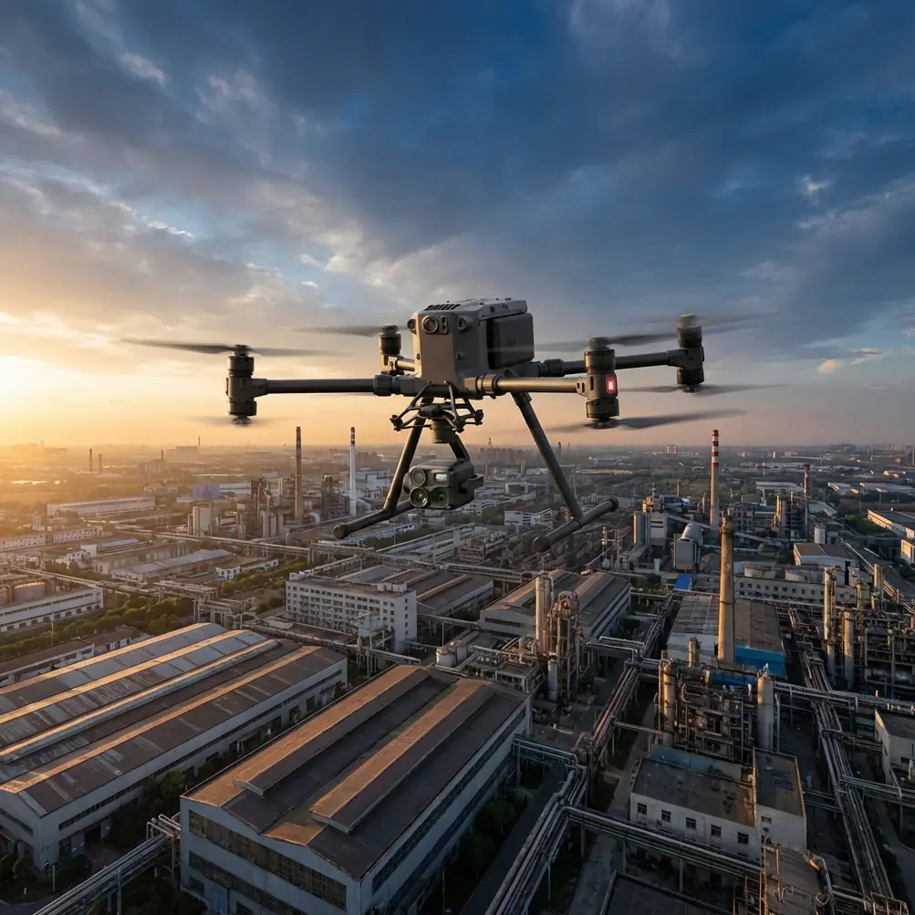
Before I look at waypoints, overlap, or altitude, I look at the aircraft itself. Specifically, I want the pilot to clean the forward, rear, upper, lower, and side sensing surfaces and the main imaging optics before the first battery goes in. Not casually. Deliberately.
Dust, crop residue, pollen, and fine moisture film are common around active fields. In low light, those contaminants can interfere with how safety features interpret the environment. An obstacle avoidance system that already has less ambient detail to work with does not need a smeared lens or a dirty sensing window making decisions harder. The same goes for the main camera: a thin film you barely notice by eye can reduce contrast enough to weaken tie-point generation later in photogrammetry.
This pre-flight cleaning step sounds minor, but operationally it is not. It protects two things at once: flight safety and mapping integrity.
My preferred sequence is simple. Power off the aircraft, inspect the body under a bright handheld light, remove loose debris with air or a soft brush, then clean optical surfaces with lens-safe materials only. After that, I check for condensation risk. A drone moved from an air-conditioned truck into humid evening air can fog more than one sensor. If you ignore that, your low-light mission starts behind schedule and below spec.
Why low light changes the mapping plan
Fields look deceptively simple from above. In reality, agricultural terrain can be difficult for aerial reconstruction when the light is weak. Repetitive crop rows reduce distinct visual features. Damp soil can flatten texture. Areas under shadow lose edge separation. If you are building an orthomosaic for crop assessment or drainage review, that means your photogrammetry settings need to be more conservative than your daytime template.
With the Matrice 4, I generally tell teams to think in terms of preserving clean image geometry rather than trying to cover maximum acreage in minimum time. That usually means lower airspeed, stronger overlap discipline, and more careful angle selection if an oblique capture segment is part of the mission.
Ground control points are especially valuable here. A good GCP layout gives the reconstruction process hard references when the visual environment is less cooperative. In a field with long repeating patterns, the software can drift if the imagery lacks strong unique points. Well-placed GCPs help lock the model down and reduce the chance that a map looks acceptable at first glance but carries positional error where it matters. If the deliverable is tied to drainage correction, planting analysis, or boundary documentation, that is not a small issue.
This is where crews sometimes overestimate thermal data as a replacement for visible-light mapping. Thermal signature analysis can be extremely useful in agriculture, especially for spotting irrigation irregularities, water stress patterns, or temperature differences near equipment and drainage lines. But thermal imagery and visible-spectrum photogrammetry serve different jobs. The Matrice 4 becomes more useful because it lets teams build a richer operational picture, not because one sensor mode magically replaces the other.
A practical example: if a field shows cooler bands consistent with overwatering or warmer patches suggesting stress, thermal signature data can tell you where to inspect first. The photogrammetry layer then gives the spatial context needed to measure, annotate, and compare those areas across time. Used together, the result is much more valuable than either dataset alone.
O3 transmission matters more over farmland than people admit
Open farmland gives pilots a false sense of communication certainty. Because the area appears unobstructed, crews assume the link will stay solid. In practice, long distances, terrain undulations, tree lines, metal structures, and edge-of-property operations can all complicate control and video transmission.
That is why O3 transmission deserves real attention in a field mapping workflow. A strong link is not just a convenience feature. It affects confidence, repositioning decisions, and the operator’s ability to monitor the mission as ambient light deteriorates. If the aircraft is working farther out at dusk, the pilot needs reliable situational awareness. Weak or unstable downlink quality increases hesitation, interrupts decision-making, and can lead operators to shorten missions before the useful area is fully covered.
For teams thinking ahead to BVLOS frameworks where regulations and approvals allow it, communication integrity becomes even more central. I am not suggesting anyone blur the regulatory lines. I am saying the Matrice 4’s transmission backbone is operationally relevant because agricultural missions often push across large tracts where robust command-and-control discipline is essential.
And if the work involves client-sensitive land data, AES-256 encryption should not be treated as a footnote. Farm boundaries, trial plots, crop-condition imagery, and infrastructure layouts are operational information. Whether the mission supports agronomy, asset inspection, or land management, strong data protection is part of a professional workflow. The aircraft is not just gathering images; it is collecting information that can influence planning and operational decisions.
Hot-swap batteries change the shape of the evening mission
Late-day mapping windows are tight. Sun angle drops quickly. Surface contrast changes by the minute. If a crew has to shut down the operation for a slow battery turnaround, the continuity of the dataset suffers.
That is where hot-swap batteries become more than a convenience. They reduce dead time between sorties and help maintain the same environmental conditions across sequential flight lines. In practical terms, that can preserve consistency in the imagery, especially when covering a larger field that requires more than one flight. If your first mission block starts under usable twilight and the second begins after a long interruption, the imagery may not stitch together as cleanly as expected because the light has changed too much.
Hot-swapping helps the team keep momentum. It also lowers the temptation to push a battery farther than is wise just to finish one more lane. In low light, with agricultural obstacles like irrigation hardware, tree margins, and occasional wires near service roads, that temptation has no place in the operation.
My field recommendation is to plan the mission in battery-sized blocks before takeoff. Do not improvise coverage after launch. Decide which zones get priority if the light drops faster than forecast. If the western edge of the field carries drainage concerns and the southern edge is routine coverage, the critical area flies first. That sounds obvious, yet many crews still launch with a broad mission plan and no ranking of what must be captured before conditions degrade.
The best low-light maps start before takeoff
The Matrice 4 is capable, but capability does not rescue a lazy workflow. Strong low-light mapping comes from a sequence:
Clean the aircraft and sensors. Confirm no film, moisture, or residue compromises the safety system. Verify camera condition. Review wind at field level and above canopy if relevant. Confirm GCP placement and visibility. Set overlap with enough margin for weak texture areas. Prioritize the mission area. Build battery transitions into the plan. Then fly with restraint.
Restraint matters. When the field is large, pilots tend to chase acreage. The better move is to protect data quality and return with a smaller, reliable dataset rather than a broad but compromised one. Low-light photogrammetry punishes optimism.
I also advise crews to use thermal output strategically, not continuously. If the goal is to identify irrigation anomalies or stress zones, collect thermal passes where temperature contrast is most likely to reveal something actionable. Then use the visible mapping mission to anchor those observations spatially. This approach is more efficient and often easier to explain to growers or land managers, because it connects “what looks different” with “where it sits in the map.”
For teams building a repeatable field program, consistency is everything. Fly similar altitudes for comparable blocks. Keep GCP methods stable. Log environmental conditions. Record the time of each sortie. Over several missions, that discipline turns isolated drone flights into a usable decision system. If you want help comparing field workflows with your operation, you can reach us directly on WhatsApp for mission planning.
What makes Matrice 4 relevant here
The Matrice 4 matters in this scenario because the platform aligns with the reality of low-light field work rather than fighting it.
Its value is not one single feature. It is the combination. O3 transmission supports confidence over larger rural properties. AES-256 addresses the fact that agricultural data can be sensitive. Hot-swap batteries protect narrow mission windows. A sensor suite capable of supporting both visual mapping and thermal signature review makes the aircraft more adaptable when one field visit needs to answer more than one question.
That adaptability is the difference between a drone that flies and a drone that fits a professional agricultural workflow.
If I were handing a checklist to a pilot heading out to map fields in low light with the Matrice 4, it would not start with software. It would start with cleaning. Then mission prioritization. Then GCP discipline. Then battery timing. That order reflects reality. Most failed low-light maps are not caused by the aircraft lacking potential. They fail because the operator did not build a process that respects the conditions.
The Matrice 4 gives crews a serious foundation for those conditions. But the aircraft only delivers its best work when the pilot treats low-light mapping as a precision job, not a leftover flight squeezed in at the end of the day.
Ready for your own Matrice 4? Contact our team for expert consultation.