Mapping High-Altitude Vineyards with Matrice 4
Mapping High-Altitude Vineyards with Matrice 4: A Reliability-First Field Case Study
META: A field-driven Matrice 4 case study on mapping high-altitude vineyards, with practical insight on reliability metrics, false alarms, fault isolation, O3 transmission, thermal signature analysis, GCP workflows, and safe logistics planning.
High-altitude vineyard mapping punishes weak workflow design.
Thin air changes aircraft behavior. Mountain light shifts fast. Sloped rows create blind spots in both planning and data review. Add cold mornings, wind shear at ridge edges, and long drives between launch points, and the usual drone checklist stops being enough. For a Matrice 4 operator working in this environment, the real question is not simply whether the aircraft can fly. It is whether the whole mission system can keep delivering usable mapping data day after day without avoidable delays.
That is where I think many conversations around Matrice 4 miss the point. People talk about sensors, transmission range, thermal signature, and photogrammetry settings, all of which matter. But in a demanding vineyard operation, the stronger lens is borrowed from manned aircraft design: reliability and maintainability. Those principles are unusually relevant when your aircraft is expected to produce repeatable map-grade outputs across many sorties on steep agricultural terrain.
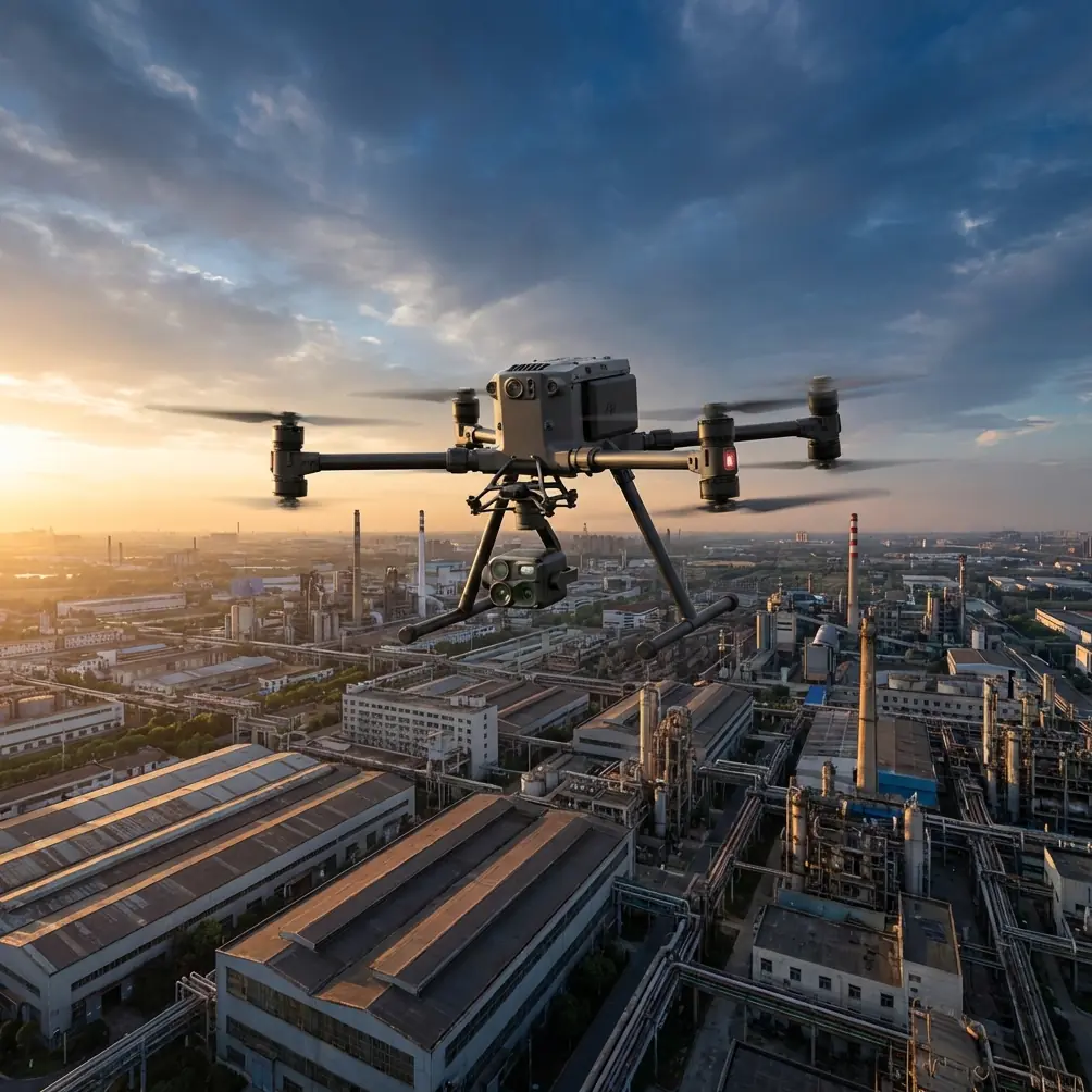
I recently worked through a vineyard mapping scenario using Matrice 4 in a high-altitude block where the grower wanted more than a pretty orthomosaic. They needed row-level visibility into plant vigor variation, drainage patterns after meltwater runoff, and heat-retention differences in select parcels. The mission was built around photogrammetry with GCP support, supplemented by thermal passes near sunrise to compare temperature behavior between terraces.
The aircraft performed well. That part was not surprising.
What stood out was how much of the success came from applying ideas that sound abstract on paper but become very practical in the field: dispatch reliability, false alarm rate, and fault isolation down to replaceable units. Those terms come from aircraft reliability engineering, not marketing material, and they deserve a place in every serious Matrice 4 workflow.
Why dispatch reliability matters more than spec-sheet excitement
In aircraft engineering, dispatch reliability is essentially the probability that a planned departure will not be delayed beyond an allowed threshold because of mechanical causes. Numerically, the underlying source defines it as 1 minus the dispatch delay rate. That sounds like a term for airline operations, yet it maps almost perfectly to commercial drone work in vineyards.
A vineyard survey window is often short. Morning light is better for surface consistency. Wind typically rises after mid-morning. Crew access on mountain roads can turn a small equipment issue into a half-day loss. In that setting, “can the drone launch as planned?” becomes one of the most important performance indicators you have.
For Matrice 4 operations, dispatch reliability is not just about the aircraft booting up. It includes:
- whether batteries are balanced and warm enough for launch
- whether the payload initializes without fault prompts
- whether RTK or GCP-dependent planning remains intact
- whether transmission is stable enough to maintain route continuity
- whether previous alerts were genuine faults or wasted troubleshooting time
The source material defines delay rate around departures affected by mechanical delay, cancellation, interruption, or equipment substitution. In a drone context, the equivalent is straightforward: delayed launches, aborted mapping legs, battery swaps forced earlier than expected, or replacing one aircraft with another because of unresolved technical flags.
That framework helped us shape the Matrice 4 mission plan. We treated every preventable preflight interruption as part of a reliability problem, not a one-off annoyance. The result was simple but effective: pre-stage batteries in insulated cases, verify payload health before driving to the highest parcel, and sequence lower-risk blocks first so the team had a clean performance baseline before tackling the windiest ridge.
That is the kind of thinking that keeps a mapping program profitable.
False alarms are not a minor nuisance in remote agriculture
Another detail from the reliability handbook is even more useful in drone operations: false alarm rate, defined as the number of false alarms divided by the total number of fault indications during a given period.
In plain language, if your system keeps telling you something is wrong when nothing actionable is actually wrong, the system is costing you time, confidence, and sometimes data continuity.
This matters a lot in high-altitude vineyard work. Conditions are harsh enough that operators already expect some friction. If warnings are poorly interpreted, crews start overreacting to harmless signals or, worse, ignoring meaningful ones. Neither is acceptable.
With Matrice 4, especially in a mixed workflow involving photogrammetry, thermal capture, and intermittent terrain masking, false alarm discipline becomes operationally significant. During our vineyard case, one segment near a rock-lined slope produced intermittent environmental noise in the sensor review process. Not a platform failure. Not a mission-ending fault. But enough to tempt an inexperienced crew into re-flying the entire block.
Instead, we evaluated the event the way an aircraft maintenance team would. Was the issue reproducible? Did it isolate to a sensor state, transmission condition, or environmental interference? Did it affect the image set or only live situational feedback? That distinction prevented an unnecessary repeat sortie.
This is where the source’s fault isolation concept is valuable. It describes the percentage of detected faults that test equipment can correctly isolate to a defined replaceable unit. For drone teams, the lesson is clear: if your workflow cannot narrow a problem to battery, payload, storage media, calibration state, or transmission path, your troubleshooting is too vague. And vague troubleshooting is how mapping crews lose windows.
A Matrice 4 team operating in vineyards should maintain its own field version of fault isolation logic. Not an academic spreadsheet. A practical tree:
- live-view anomaly only
- captured-data anomaly
- payload initialization issue
- GNSS or GCP alignment concern
- battery behavior issue
- route execution issue
- terrain or vegetation occlusion issue
That level of structure reduces panic and protects your sortie count.
The wildlife moment that tested the sensors
There was one memorable pass just after sunrise that reminded me why sensor interpretation matters as much as sensor quality.
We were running a thermal-supported observation leg over a terrace edge where the vineyard bordered scrub and loose stone. A heat signature appeared at row margin level, moving across the planned flight corridor. At first glance it looked like a warm patch reflecting from rock mass that had held overnight temperature differently than the surrounding soil. A second look showed motion. Then shape.
It was a roe deer moving between vine breaks.
The Matrice 4’s sensor view let us identify the movement early enough to hold the line and adjust the pass without pushing the animal deeper into the cultivated block. That matters operationally for two reasons. First, it avoided collecting a compromised image sequence caused by an abrupt manual correction too late in the run. Second, it showed the practical value of thermal signature awareness in agricultural environments where wildlife, livestock, irrigation hardware, and sun-heated terrain can all present confusing visual patterns.
This is where thermal work in vineyards stops being a brochure feature. It becomes an interpretation discipline. At altitude, temperature contrast can be sharp at dawn and then collapse quickly as sunlight reaches alternating slopes. If you are using Matrice 4 thermal outputs to support crop stress assessments or water management observations, the crew needs to know what is plant-related, what is terrain-related, and what is simply a moving animal crossing the frame.
O3 transmission and AES-256 only matter if they protect mission continuity
High-altitude vineyards are famous for line-of-sight surprises. You think you have a clean corridor, then a fold in the terrain or a row of taller windbreak trees creates a partial mask. That is why O3 transmission capability deserves practical attention. Not because of headline range claims, but because stable link behavior supports consistent route execution and cleaner operator decisions when terrain complexity rises.
On our Matrice 4 runs, transmission resilience mattered most when moving from one terrace to another with elevation discontinuities. A stable link reduces the temptation to overcorrect aircraft position, pause too often, or break route rhythm in ways that complicate photogrammetry processing later. Mapping quality is not just about overlap settings. It is also about smoothness and consistency during acquisition.
AES-256 encryption also belongs in this discussion, although for a different reason. Vineyard mapping often involves proprietary agricultural data: block productivity trends, irrigation layouts, terrain models, access roads, and infrastructure locations. Secure transmission is not abstract IT hygiene. It is part of professional handling of client-sensitive spatial data. For growers working across multiple estates or contract operators serving premium wine regions, that can be a deciding factor in whether a drone workflow is considered mature enough for regular deployment.
GCP discipline still wins in difficult terrain
No serious high-relief vineyard mapping plan should assume terrain complexity will forgive weak control.
Even with strong onboard positioning, GCPs remain one of the best ways to anchor outputs when working across steep gradients, retaining walls, mixed canopy density, and repeating row geometry. Vineyards can be visually deceptive in processing because row repetition creates a kind of patterned confidence that is not always true confidence. Good control points break that illusion.
We used GCPs selectively rather than blanketing the entire property. The placement strategy focused on elevation transitions, terrace corners, and one drainage crossing where surface texture changed significantly. That reduced the risk of local warping in the final photogrammetry deliverables.
The broader point is that Matrice 4 can produce excellent mapping data, but difficult sites still reward old-fashioned survey discipline. The aircraft is a high-performance collection tool, not a substitute for control logic.
Thinking in overhaul intervals, not just flight days
One of the more overlooked details in the reference material is the distinction between time to first overhaul, time between overhauls, and total life. Those are classic aviation maintenance concepts, and they fit mature drone programs surprisingly well.
For a vineyard operator or service provider using Matrice 4 intensively through growing season, this way of thinking is useful:
- time to first overhaul becomes your expected service interval before major preventive attention
- time between overhauls becomes your recurring maintenance cadence
- total life becomes the realistic planning horizon for the aircraft or key components before retirement
Why does this matter? Because mapping businesses often track flight hours but fail to connect them to mission risk. A drone can still be flying while quietly losing dispatch reliability. Gimbal wear, connector fatigue, battery aging, cooling performance drift, and storage-media issues rarely announce themselves politely. They usually show up first as small delays, inconsistent starts, or unexplained data review problems.
That is exactly why the reliability source also includes concepts like storage life and service life. Vineyard teams often have seasonal operating peaks. Aircraft or batteries may sit between campaigns. If storage conditions are poor, your first launch window in a critical block can vanish into preventable troubleshooting.
If you are building a repeatable Matrice 4 program, document not only flight count but also:
- calendar age of batteries and accessories
- storage intervals between peak operations
- frequency of non-actionable alerts
- number of sorties delayed by setup or initialization issues
- repeat component-level anomalies
That is how a drone fleet starts behaving like a professional aviation asset instead of a gadget.
A cargo-handling lesson that actually applies to drone fieldwork
The second source document is about civil aircraft cargo compartments, which sounds far removed from a vineyard survey. It is not.
One section specifies that when vehicles or equipment move across a cargo bridge slope, wheel chocks should be placed behind the wheels to prevent rollback. Another addresses restraint systems designed to stop cargo from surging forward in an emergency, including the use of barrier nets because aircraft restraint hardware alone may struggle to meet a 9g forward-load requirement.
For Matrice 4 field crews, the lesson is logistics discipline. High-altitude vineyard work often involves unloading batteries, charging kits, landing pads, GNSS gear, and cases on uneven ground, near slopes, sometimes in low light. Equipment security is not just vehicle etiquette. It is operational protection for the mission.
I have seen more than one survey day compromised not by aircraft issues, but by ground-handling sloppiness: a case sliding on an incline, a battery station set on unstable terrain, or a support vehicle parked poorly near a terrace access road. The cargo handbook’s logic is simple and timeless: restrain what can move before movement creates risk.
Even the document’s container dimensions tell a story. Main-deck cargo standards such as 88in x 125in and 96in x 125in exist because repeatable logistics demand known packaging geometries. Drone teams can apply the same principle at a smaller scale. Standardize case layout, battery transport, spare-part segregation, and loading order. When you are bouncing between vineyard blocks at altitude, that standardization improves setup speed and reduces missed items.
The result: better maps because the operation was better
The final vineyard deliverables were solid: clean orthomosaic coverage, usable terrain-informed outputs, and thermal context that helped the grower compare block behavior across elevation bands. But the more interesting result was procedural.
The Matrice 4 did not just succeed because it has capable sensors and modern transmission. It succeeded because the mission was run with aviation-grade respect for reliability, maintainability, and logistics control. Dispatch reliability reduced lost launch windows. False alarm discipline prevented unnecessary reflights. Fault isolation thinking kept troubleshooting precise. GCP placement stabilized outputs where terrain could have introduced subtle distortion. Ground logistics prevented the sort of equipment mishandling that ruins a field day before takeoff.
If you are planning similar work and want to compare high-altitude vineyard workflows, sensor choices, or control strategies, you can send field details here: message James directly.
That is the real story around Matrice 4 in this kind of environment. Not hype. Not abstract capability. A dependable aerial mapping system becomes valuable when every part of the job, from launch readiness to data trustworthiness, is treated as part of one integrated operation.
Ready for your own Matrice 4? Contact our team for expert consultation.