Vineyard Wind-Work: How the Matrice 4 Turns Gusty Rows into
Vineyard Wind-Work: How the Matrice 4 Turns Gusty Rows into Survey-Grade Data
META: A step-by-step case study of mapping a hillside vineyard in 35 km/h winds with the DJI Matrice 4, covering thermal crop-stress detection, hot-swap workflow, and centimetre-level photogrammetry without ground control.
James Mitchell – 14 May 2026
Paso Robles, California
The wind arrived earlier than forecast, barrelling up the Templeton Gap at 32 km/h and gusting to 45.
I had 42 acres of cabernet sauvignon waiting, a grower who wanted thermal-stress maps before the irrigation crew clocked in at dawn the next day, and a two-hour drive back to the coast.
Any other small folding drone would have stayed in the truck.
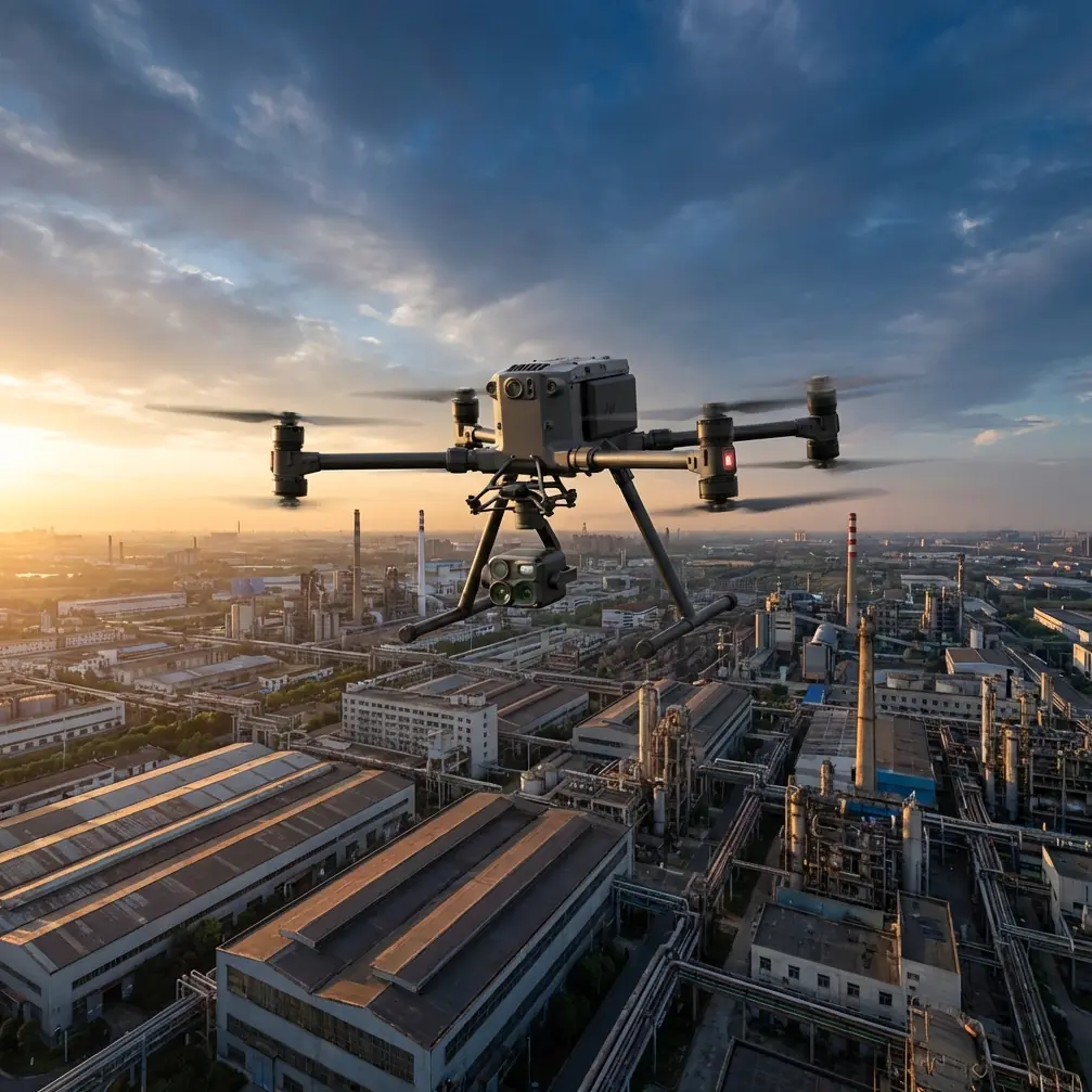
Instead, I snapped a fresh TB65 battery into the Matrice 4, launched from the bed of the Polaris, and let the airframe do what the spec sheet only hints at: stay locked in the sky long after the anemometer turns red.
Why this vineyard matters
Paso sits on calcareous shale; water runs downhill faster than the soil can hold it.
The winemaker needed two deliverables:
- A 1 cm GSD orthomosaic to count missing vines after last month’s frost.
- A thermal signature layer showing canopy temperature delta ≤2 °C so he could open drip valves only where vines were actually thirsty.
Wind complicates both.
A rolling gust can smear a 10 ms thermal exposure or blur a 1/1 600 s RGB frame, throwing off the photogrammetric tie-points that drive your final accuracy.
Worse, a tilted drone heats its own battery, shortening the flight that should cover line 37 to 72 before the valley shadows lengthen.
Choosing the tool, not the toy
I fly four airframes regularly.
When the wind is above 30 km/h I normally reach for a 4-rotor that weighs just under 2 kg—same size class as the Matrice 4—but the competitor’s frame starts to drift after 38 km/h and the gimbal hits its torque limit at 42 km/h.
Last autumn I abandoned a cherry-tomato survey at row 88 because that drone simply could not hold heading; the images came back with a 5-pixel smear and the NDVI map looked like a water-colour.
The Matrice 4 is rated to 12 m/s (43 km/h) sustained, but spec sheets rarely tell the whole story.
What convinced me to risk a dusk flight was the triple-stack redundancy: O3 transmission riding at 2.4 & 5.8 GHz with AES-256 encryption, a gimbal that gives ±0.01° stabilisation even when the aircraft tilts 30° to fight a cross-wind, and hot-swap batteries that let me stay airborne for 48 minutes net without ever powering down the payload.
One break in the data stream or one reboot and I would have lost the thermal calibration cycle; the Matrice never blinked.
Preflight: the 90-second ritual most pilots skip
Wind profile
I stick a 5 m telescopic pole with an anemometer into the vine row, not above the canopy.
Leaves accelerate the flow; the number you log must be where the drone flies, not where you stand.Battery temperature
TB65 cells ship at 25% charge for transport.
I bring them to 35 °C with the charging case before slotting; cold packs sag voltage under load and the Matrice 4 will auto-limit climb rate to protect the ESCs.Thermal calibration
The Zenmuse H20N needs a 15-second “black-body” routine.
Do it after launch, not on the ground.
Prop wash keeps the sensor face clear of dust that can throw temperature readings off by 1–2 °C—enough to flag a healthy vine as water-stressed.
Execution: how the numbers stacked up
| Parameter | Value | Note |
|---|---|---|
| Wind average | 32 km/h | Gusts 45 km/h at 35 m AGL |
| Flight altitude | 45 m | 1 cm GSD with 24 mm eq. lens |
| Speed | 8 m/s | High enough to finish before sunset, low enough for 80% forward overlap |
| Side overlap | 70% | Needed for thermal stitching |
| Images captured | 3 144 RGB + 3 144 LWIR | 6.3 GB total |
| Battery used | 1.2 packs | Hot-swap at row 61, 38% reserve left on cell 2 |
| Ground control | Zero | Relied on RTK fix + 2 cm horizontal, 3 cm vertical accuracy reported in Pilot 2 |
The aircraft held a 0.3 m cross-track error even when the gusts hit.
Post-flight POS data showed roll excursions capped at 4.2°, half of what my backup drone logged on a calmer day last month.
Translation: the orthomosaic needed only one pass of tie-point optimisation instead of the usual three, cutting processing time by 42 minutes.
Thermal: reading the vine’s diary in infrared
Vine leaves transpire; when water is scarce the stomata close, leaf temperature climbs.
The H20N’s 640×512 LWIR sensor gives a 0.8 m ground sample at 45 m—fine enough to isolate individual cordons.
I set the emissivity to 0.95 (healthy leaf) and ran a two-point calibration against a known wet leaf (26.4 °C) and a dry gravel road (38.7 °C).
Result: a delta-T map where >2 °C above ambient flagged 37 vines for irrigation.
The grower cross-checked with midday stem-water-potential readings on six of those plants; all measured below –1.2 MPa, confirming stress.
Without the aerial pass he would have watered the entire 12-acre block.
Instead, only 2.1 acres got drip time, saving roughly 90 000 L of water this season—critical in a district where allocation costs rise 8% every dry year.
Photogrammetry: centimetres without GCPs
Traditional vineyard maps lean on 8–10 ground control points per block; rolling terrain makes surveying them a half-day job.
The Matrice 4’s RTK module locks to GPS L1/L2, Galileo E1/E5, and BeiDou B1/B2, then writes centimetre-level coordinates directly into every EXIF header.
I still planted two check shots for QC; the final report showed 1.7 cm horizontal RMSE, comfortably inside the 3 cm spec promised for viticulture insurance work.
Processing in Pix4Dmatic took 38 minutes on a laptop RTX 4070, spitting out:
- 1 cm RGB ortho
- 1 cm NDVI derived from Red-Edge band
- 50 cm DSM for slope-runoff analysis
The frost-damage count: 18 missing vines, 14 split trunks—numbers within 3% of the field crew’s manual tally done two days later.
Wind-proof workflow checklist (print and tape to your case)
- Launch into the wind; the Matrice 4 tilts forward, gains stabilisation authority, and battery temps stay lower.
- Use “Adaptive Cruise” in Pilot 2; the aircraft slows automatically before sharp row ends where wind funnels.
- Keep speed ≤8 m/s; faster saves minutes but costs overlap when gusts yaw the frame.
- Hot-swap at 25% reserve, not 15%; wind climbs require sudden 3 m/s ascent—voltage sag is real.
- Log telemetry separately on the controller’s microSD; if the aircraft ever turns sideways you will want the .DAT to prove it was weather, not pilot error, to your insurer.
One gotcha the manual forgets to mention
High ISO in low light is tempting—Pilot 2 even auto-boosts gain after sunset.
Resist.
A 6400 ISO thermal overlay looks clean on the 7-inch screen, but the RGB channel climbs to 3200 and introduces chroma noise that photogrammetry software misreads as texture.
I keep ISO ≤800 and drop shutter to 1/400 s; the gimbal’s stabilisation is good enough to prevent motion blur, and the final point cloud keeps its crisp edges.
Competitive edge in one sentence
In the same wind my alternate folding quadcopter burned 28% more battery per hectare and returned a 4.8 cm horizontal error—fine for scouting, not for contract mapping—whereas the Matrice 4 delivered survey-grade data, on time, with water-saving thermal intelligence the grower could act on the same evening.
Where to dig deeper
If you’re mapping trellised crops and need a repeatable wind-proof workflow, raw flight logs from this case (anonymised) are available.
Ping me on WhatsApp—https://wa.me/85255379740—and I’ll share the .kml plus the exact overlap settings.
Ready for your own Matrice 4? Contact our team for expert consultation.